IMAGES TAKEN NEAR TO
Hinton Wood Avenue, CHRISTCHURCH, BH23 5AD
Introduction
This page details the photographs taken nearby to Hinton Wood Avenue, BH23 5AD by members of the Geograph project.
The Geograph project started in 2005 with the aim of publishing, organising and preserving representative images for every square kilometre of Great Britain, Ireland and the Isle of Man.

There are currently over 7.5m images from over14,400 individuals and you can help contribute to the project by visiting https://www.geograph.org.uk
Image Map
Images are licensed for reuse under creativecommons.org/licenses/by-sa/2.0
Notes
- Clicking on the map will re-center to the selected point.
- The higher the marker number, the further away the image location is from the centre of the postcode.
Image Listing (77 Images Found)
Images are licensed for reuse under creativecommons.org/licenses/by-sa/2.0
Image
Details
Distance
1
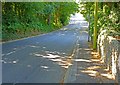
Hinton Wood Avenue, Highcliffe, Dorset
This through route between the A337 Lymington Road and the A35 Christchurch road is lined with large expensive houses.
Image: © mike smith
Taken: 2 Sep 2013
0.04 miles
2
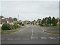
Housing estate, Highcliffe
This idyllic-looking housing estate with its chalet-style bungalows is a stone's throw away from Highcliffe Castle, on the road that goes up to Hinton Admiral station
Image: © GaryReggae
Taken: 26 Aug 2006
0.05 miles
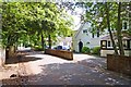
3
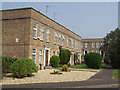
Georgian-style Town Houses
This is part of a small estate of modern terraced town houses, off Kilmington Way, Highcliffe.
Image: © mike smith
Taken: 15 Apr 2007
0.07 miles
4
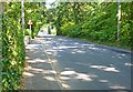
Hinton Wood Avenue, Highcliffe, Dorset
This through route between the A337 Lymington Road and the A35 Christchurch road is lined with large expensive houses.
Image: © mike smith
Taken: 2 Sep 2013
0.07 miles
5
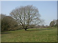
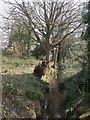
Nea Meadows, oak tree
One of several old, large oak trees on Image This one must have been coppiced a long time ago, given its sturdy regrowth.
Image: © Mike Faherty
Taken: 20 Mar 2009
0.08 miles
6
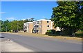
Earlesdon Way, Highcliffe, Dorset
There are several blocks of flats in this immediate area.
Image: © mike smith
Taken: 4 Sep 2013
0.09 miles
7
Nea Meadows, stream
One of the streams feeding the lake at Image, which then form Bure Brook and flow into Christchurch Harbour.
Image: © Mike Faherty
Taken: 20 Mar 2009
0.09 miles
8
Firshill, Highcliffe, Dorset
This pleasant cul-de-sac is lined with attractive bungalows.
Image: © mike smith
Taken: 2 Sep 2013
0.11 miles
9
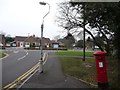
Highcliffe: postbox № BH23 22, Hinton Wood Avenue
This George V-reign postbox is emptied finally at 5pm on weekdays and at 12:15pm on Saturdays. It stands, with a slight lean to the south, on the corner of Hinton Wood Avenue (right and behind) and Castle Avenue (left). The junction with Nea Road can also be seen ahead of us.
Image: © Chris Downer
Taken: 31 Jan 2009
0.13 miles
10
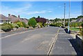
Nea Road, Highcliffe, Dorset
Nea Road is named after the Nea Farm which used to occupy this area until the early 20th century.
Image: © mike smith
Taken: 5 Jul 2012
0.14 miles