IMAGES TAKEN NEAR TO
Bure Haven Drive, CHRISTCHURCH, BH23 4BS
Introduction
This page details the photographs taken nearby to Bure Haven Drive, BH23 4BS by members of the Geograph project.
The Geograph project started in 2005 with the aim of publishing, organising and preserving representative images for every square kilometre of Great Britain, Ireland and the Isle of Man.

There are currently over 7.5m images from over14,400 individuals and you can help contribute to the project by visiting https://www.geograph.org.uk
Image Map (Loading...)


Getting Data...Please wait
Leaflet Map data © OpenStreetMap
Images are licensed for reuse under creativecommons.org/licenses/by-sa/2.0
Notes
- Clicking on the map will re-center to the selected point.
- The higher the marker number, the further away the image location is from the centre of the postcode.
Image Listing (15 Images Found)
Images are licensed for reuse under creativecommons.org/licenses/by-sa/2.0
Image
Details
Distance
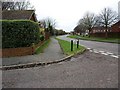
2
Mudeford: postbox № BH23 92, Lark Road
Easily the shortest of several neighbouring roads named after birds, Lark Road has just a couple of properties on each side. The Elizabeth II-reign postbox is emptied finally at 5:30pm on weekdays and at 12:15pm on Saturdays.
Image: © Chris Downer
Taken: 14 Jul 2009
0.07 miles
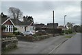
4
De Havilland Way, at the junction with Bure Homage Lane
Image: © David Gearing
Taken: 28 Feb 2011
0.20 miles
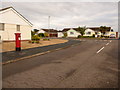
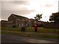
5
Bungalows along Bure Lane, Christchurch
Image: © David Smith
Taken: 29 Mar 2017
0.21 miles
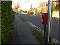
6
Mudeford: postbox № BH23 102, de Havilland Way
This postbox stands in an area with roads named after two things – the former airfield here (names such as de Havilland Way, The Runway and Airfield Way) and various birds (the signpost points down a walkway to houses in Grebe Close, Curlew Road and Mallard Close).
The box is emptied finally at 5:30pm on weekdays and at 12:30pm on Saturdays.
Image: © Chris Downer
Taken: 14 Jul 2009
0.21 miles
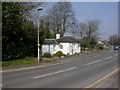
7

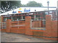
The Sunken Car Park
This is just behind the Avon Beach café, but is not visible from the beach area. As a result, cars often queue for a space in the beach car park, when spaces are available here.
Image: © mike smith
Taken: 18 Jul 2007
0.23 miles
8
Christchurch: postbox № BH23 71, Friars Road
Looking north along Friars Road, past this small postbox mounted on a pole.
Image: © Chris Downer
Taken: 28 Dec 2008
0.23 miles
9
Friar's Cliff, Bure Homage Lodge
Former lodge house in Bure Lane; early C19, English Heritage-listed http://www.imagesofengland.org.uk/Details/Default.aspx?id=101434&mode=adv Note the windows with pointed arches.
Image: © Mike Faherty
Taken: 20 Mar 2009
0.23 miles
10
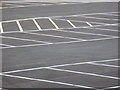
Mudeford: car park markings
Looking across the empty half of this pay-and-display car park. The yellow diagonal lines mark a no-parking area to keep access free flowing given the car park's odd semicircular shape.
Image: © Chris Downer
Taken: 1 Jul 2012
0.23 miles