IMAGES TAKEN NEAR TO
Asquith Close, CHRISTCHURCH, BH23 3DX
Introduction
This page details the photographs taken nearby to Asquith Close, BH23 3DX by members of the Geograph project.
The Geograph project started in 2005 with the aim of publishing, organising and preserving representative images for every square kilometre of Great Britain, Ireland and the Isle of Man.

There are currently over 7.5m images from over14,400 individuals and you can help contribute to the project by visiting https://www.geograph.org.uk
Image Map (Loading...)


Getting Data...Please wait
Leaflet Map data © OpenStreetMap
Images are licensed for reuse under creativecommons.org/licenses/by-sa/2.0
Notes
- Clicking on the map will re-center to the selected point.
- The higher the marker number, the further away the image location is from the centre of the postcode.
Image Listing (44 Images Found)
Images are licensed for reuse under creativecommons.org/licenses/by-sa/2.0
Image
Details
Distance
1
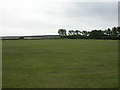
Stanpit Recreation Ground
Large open space owned by Christchurch Borough Council, popular with dog walkers; Christchurch Harbour and Hengistbury Head visible in the distance.
Image: © Mike Faherty
Taken: 6 Aug 2009
0.02 miles
2
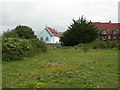
Stanpit, old rubbish tip
Off Stanpit, old rubbish tip, now part of the recreation ground & nature reserve. Interestingly, contains plants that would not normally be found in this habitat, perhaps because of soil tipped here: Traveller's joy (in hedge, to left), Autumn lady's tresses, Bloody cranesbill, Salad burnet. Visible here: Birdsfoot trefoil (yellow), Common centaury (pink). New-build housing in the background.
Image: © Mike Faherty
Taken: 6 Aug 2009
0.06 miles

4
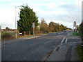
Stanpit, Christchurch, Dorset
This road scene shows a junction, with school playing fields to the left. Stanpit borders Christchurch harbour.
Image: © Stuart Buchan
Taken: 4 Nov 2005
0.10 miles
5
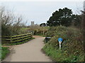
Shared path across Stanpit Marsh, Christchurch
A path for walking and cycling on Stanpit Marsh in Christchurch. This path is on route 2 of the National Cycle Network.
Christchurch Priory stands in the background.
Image: © Malc McDonald
Taken: 29 Dec 2024
0.11 miles
6
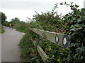
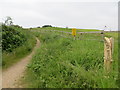
Stanpit, path markers
Markers for the E9 long-distance path, here, the section from Christchurch to Milford. http://www.annierak.hoofbags.me.uk/bournemouthcoast.html
Image: © Mike Faherty
Taken: 6 Aug 2009
0.11 miles
7
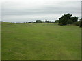
Two Riversmeet Golf Course
South-west of Christchurch town centre; the priory visible in the distance. http://www.uk-golfguide.com/england/17734.html?
Image: © Mike Faherty
Taken: 6 Aug 2009
0.12 miles
8
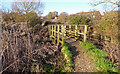
Footbridge at Stanpit Marsh
This simple wooden footbridge spans one of many drainage channels on the marsh.
Housing has been built nearby, as can be seen.
Image: © mike smith
Taken: 8 Feb 2011
0.12 miles
9
Footpath to Priory Marsh
Looking south-eastward.
Image: © Peter Wood
Taken: 4 Jun 2016
0.12 miles