IMAGES TAKEN NEAR TO
Huntingdon Gardens, CHRISTCHURCH, BH23 2TW
Introduction
This page details the photographs taken nearby to Huntingdon Gardens, BH23 2TW by members of the Geograph project.
The Geograph project started in 2005 with the aim of publishing, organising and preserving representative images for every square kilometre of Great Britain, Ireland and the Isle of Man.

There are currently over 7.5m images from over14,400 individuals and you can help contribute to the project by visiting https://www.geograph.org.uk
Image Map (Loading...)


Getting Data...Please wait
Leaflet Map data © OpenStreetMap
Images are licensed for reuse under creativecommons.org/licenses/by-sa/2.0
Notes
- Clicking on the map will re-center to the selected point.
- The higher the marker number, the further away the image location is from the centre of the postcode.
Image Listing (20 Images Found)
Images are licensed for reuse under creativecommons.org/licenses/by-sa/2.0
Image
Details
Distance
1
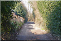
Marsh Lane, Christchurch
Despite the considerable housing development in the area, this section of Marsh Lane remains a dirt road.
Image: © mike smith
Taken: 4 Mar 2011
0.04 miles
2
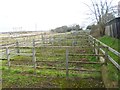
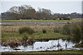
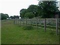
Coward's Marsh, stock pens
Used by commoners who graze their cattle and horses on the adjoining grazing land.
Image: © Mike Faherty
Taken: 27 Jan 2015
0.05 miles
3
Christchurch, Marsh Lane
Lane and bridleway, from Suffolk Avenue to Coward's Marsh.
Image: © Mike Faherty
Taken: 27 Jan 2015
0.06 miles
4
Cowards Marsh, pound
Pound where commoners at Image can keep their stock before or after being let out to graze.
Image: © Mike Faherty
Taken: 21 May 2009
0.06 miles
5
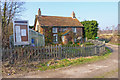
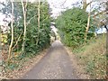
Old Cottage by Coward's Marsh
This cottage is right alongside the track of an old railway line which ran from Ringwood to Christchurch, but was closed in the 1930s. It is possible that the dwelling was a railway house, but there is no proof of that.
Image: © mike smith
Taken: 4 Mar 2011
0.06 miles
6
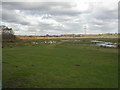
Coward's Marsh, Christchurch
Christchurch Commoners, who have to be residents of Twynham or Portfield Wards and pay council tax, may graze animals here from Lammas to Candlemas (May-Feb). The maximum number allowed is 12 cattle, excluding bulls, or 6 horses/donkeys/mules. Difficult to tell in such a flat landscape, but the marsh may be over-populated. Also popular with swans. Taken from Marsh House looking towards the Avon.
Image: © Mike Faherty
Taken: 31 Oct 2008
0.06 miles
7
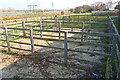
Livestock Pens at Coward's Marsh
Livestock is kept on the water meadows by "commoners". These pens are used when the animals are removed from the common land.
Image: © mike smith
Taken: 4 Mar 2011
0.07 miles
8
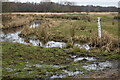
Depth marker and drainage ditch on Coward?s Marsh
The marker stands where a track crosses the ditch and presumably provides some reassurance when the whole area is under water. Judging from a nearby spot height, the red figure “4” indicates 4 metres above sea level.
Image: © David Martin
Taken: 22 Jan 2022
0.10 miles
9
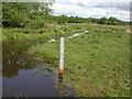
Cowards Marsh, gaugeboard
Gaugeboard showing the water level at Image; being in the floodplain of the River Avon, ground here is damp, but drains quickly because of sandy soil.
Image: © Mike Faherty
Taken: 21 May 2009
0.10 miles