IMAGES TAKEN NEAR TO
Bronte Avenue, CHRISTCHURCH, BH23 2ND
Introduction
This page details the photographs taken nearby to Bronte Avenue, BH23 2ND by members of the Geograph project.
The Geograph project started in 2005 with the aim of publishing, organising and preserving representative images for every square kilometre of Great Britain, Ireland and the Isle of Man.

There are currently over 7.5m images from over14,400 individuals and you can help contribute to the project by visiting https://www.geograph.org.uk
Image Map
Images are licensed for reuse under creativecommons.org/licenses/by-sa/2.0
Notes
- Clicking on the map will re-center to the selected point.
- The higher the marker number, the further away the image location is from the centre of the postcode.
Image Listing (7 Images Found)
Images are licensed for reuse under creativecommons.org/licenses/by-sa/2.0
Image
Details
Distance
1
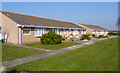
Terraced Bungalows on Marsh Lane
There are several rows of these smart terraced bungalows, which are right on the edge of the water meadows, overlooking the River Avon.
Image: © mike smith
Taken: 4 Mar 2011
0.02 miles
2
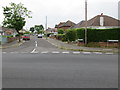
The junction of Flambard Avenue with Marsh Lane
Looking south-westward along Flambard Avenue.
Image: © Peter Wood
Taken: 4 Jun 2016
0.05 miles
3
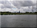
River Avon at Fairmile
Power lines and gravel extraction plant mar this view across the meadows from the river Avon towards Fairmile.
Image: © Barry Deakin
Taken: 28 Apr 2008
0.16 miles
4
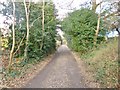
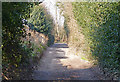
Christchurch, Marsh Lane
Lane and bridleway, from Suffolk Avenue to Coward's Marsh.
Image: © Mike Faherty
Taken: 27 Jan 2015
0.22 miles
5
Marsh Lane, Christchurch
Despite the considerable housing development in the area, this section of Marsh Lane remains a dirt road.
Image: © mike smith
Taken: 4 Mar 2011
0.23 miles
6
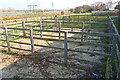
Livestock Pens at Coward's Marsh
Livestock is kept on the water meadows by "commoners". These pens are used when the animals are removed from the common land.
Image: © mike smith
Taken: 4 Mar 2011
0.24 miles
7
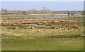
River Avon Water Meadows
These meadows are at the southern end of Coward's Marsh, which is public access land.
Image: © mike smith
Taken: 4 Mar 2011
0.25 miles