IMAGES TAKEN NEAR TO
The Meridians, CHRISTCHURCH, BH23 1RA
Introduction
This page details the photographs taken nearby to The Meridians, BH23 1RA by members of the Geograph project.
The Geograph project started in 2005 with the aim of publishing, organising and preserving representative images for every square kilometre of Great Britain, Ireland and the Isle of Man.

There are currently over 7.5m images from over14,400 individuals and you can help contribute to the project by visiting https://www.geograph.org.uk
Image Map (Loading...)


Getting Data...Please wait
Leaflet Map data © OpenStreetMap
Images are licensed for reuse under creativecommons.org/licenses/by-sa/2.0
Notes
- Clicking on the map will re-center to the selected point.
- The higher the marker number, the further away the image location is from the centre of the postcode.
Image Listing (107 Images Found)
Images are licensed for reuse under creativecommons.org/licenses/by-sa/2.0
Image
Details
Distance
1
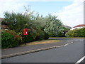
Christchurch: postbox № BH23 400, Wentworth Drive
This small postbox serves the modern housing estate, The Meridians. It is emptied finally at 5:30pm on weekdays and at 12:30pm on Saturdays.
Image: © Chris Downer
Taken: 30 Jun 2009
0.06 miles
2
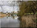
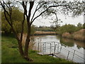
Christchurch, river bank
Looking upstream at the River Avon bank from Stocker's Field, with Homelands in the distance.
Image: © Mike Faherty
Taken: 24 Feb 2011
0.06 miles
3
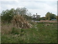
Christchurch, pampas grass
Looking distinctly out of place on open land next to the River Stour; in the distance, on the other bank, Image
Image: © Mike Faherty
Taken: 5 May 2010
0.07 miles
4

Stour Roundabout
The junction of Stour Road (B3059) with The Meridans and Willow Drive, Christchurch.
Image: © David Dixon
Taken: 4 Aug 2010
0.07 miles
5
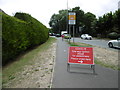
Christchurch, pedestrian notice
Normally, pavements on both sides of Tuckton Bridge are two-way. BCP Council has made them one-way, to comply with social distancing requirements during Covid 19.
Image: © Mike Faherty
Taken: 3 Jul 2020
0.07 miles
6
Christchurch, River Stour
Looking downstream from open land behind Image
Image: © Mike Faherty
Taken: 5 May 2010
0.08 miles
7
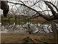
Iford: across the river from under a fallen tree
Looking across the River Stour from a short beachy section of the riverbank, accessible just off Iford playing fields. We are under a tree that has long fallen and is strutting its branches high above the river.
Image: © Chris Downer
Taken: 5 Jan 2019
0.09 miles
8
River Stour at Tuckton
This is a view looking east, with Tuckton Bridge in the background.
Image: © mike smith
Taken: 13 Aug 2007
0.10 miles
9
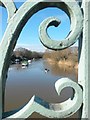
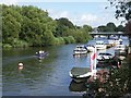
Tuckton: a kayaker on the Stour
Looking upstream along the Stour through the bright, ornate ironwork of Tuckton Bridge as a man kayaks towards us down the centre of the river.
Image: © Chris Downer
Taken: 17 Feb 2018
0.10 miles
10
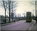
Bournemouth trolleybus on Tuckton Bridge (2)
A Sunbeam MF2B trolleybus crossing the River Stour at Tuckton Bridge on route 21 from Bournemouth town centre to Christchurch via Boscombe, Pokesdown and Southbourne. This vehicle with a YLJ registration number has Weymann 63-seater bodywork dating from 1959. The trolleybus warning notice and the Bournemouth nameplate can be seen to the left of the bridge.
Image: © David Hillas
Taken: 5 Apr 1969
0.10 miles