IMAGES TAKEN NEAR TO
Fairfield Close, CHRISTCHURCH, BH23 1QZ
Introduction
This page details the photographs taken nearby to Fairfield Close, BH23 1QZ by members of the Geograph project.
The Geograph project started in 2005 with the aim of publishing, organising and preserving representative images for every square kilometre of Great Britain, Ireland and the Isle of Man.

There are currently over 7.5m images from over14,400 individuals and you can help contribute to the project by visiting https://www.geograph.org.uk
Image Map
Images are licensed for reuse under creativecommons.org/licenses/by-sa/2.0
Notes
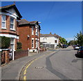
- Clicking on the map will re-center to the selected point.
- The higher the marker number, the further away the image location is from the centre of the postcode.
Image Listing (217 Images Found)
Images are licensed for reuse under creativecommons.org/licenses/by-sa/2.0
Image
Details
Distance
1
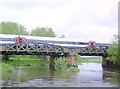
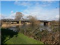
Railway bridge over River Avon
The London & South Western Railway opened its Bournemouth Direct line between Brockenhurst and Christchurch in 1888. This iron bridge carries the rails over the River Avon. A South West Trains service is crossing. The Avon Valley Path passes under the bridge and provided this viewpoint.
Image: © J D Smith
Taken: 23 May 2006
0.03 miles
2
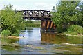
Low Bridge for Walkers
This is a footpath under the railway bridge. The low headroom sign is presumably to warn tall walkers!
Image: © mike smith
Taken: 5 Jul 2010
0.03 miles
3
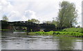
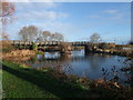
Railway bridge over the river Avon
Looking downstream through the railway bridge.
Image: © Barry Deakin
Taken: 28 Apr 2008
0.04 miles
4
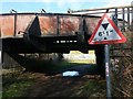
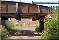
Christchurch: 6' 1" headroom on the riverside path
The Image unsurprisingly also crosses the public footpath along the riverbank, and the road sign here illustrates the low level at which the railway passes overhead.
In reality, this will be a route little used by vehicles as it is just access for maintenance vehicles, and even then I'm not sure that there is all that much to maintain.
Image: © Chris Downer
Taken: 17 Feb 2018
0.04 miles
5
Christchurch: railway bridge over the Avon
Looking upstream along the Avon from the riverside path, past the railway bridge which crosses at a relatively low level (see Image).
Image: © Chris Downer
Taken: 17 Feb 2018
0.04 miles
6
The Avon Valley Path leaving Christchurch
About to pass under the Southampton-Bournemouth main line
Image: © Tim Heaton
Taken: 26 Jan 2012
0.05 miles
7
Christchurch, WWII defences
Pill box and anti-tank blocks, guarding the Bournemouth to Southampton railway line, in what is now Avon Trading Park; Image in the background.
Image: © Mike Faherty
Taken: 28 Aug 2010
0.06 miles
8
River Avon, Christchurch
This shows the Avon passing under one of the spans of the railway bridge at Christchurch.
Image: © mike smith
Taken: 5 Jul 2010
0.06 miles
9
Past a bend in Fairfield, Christchurch
Fairfield traces a roughly rectangular route between the B3073 Bargates and the west bank of the River Avon.
This part of Fairfield is past the left turn into Lights Close. http://www.geograph.org.uk/photo/5089259
Image: © Jaggery
Taken: 24 Aug 2016
0.06 miles
10
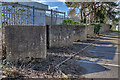
WWII defences in the environs of Bournemouth & Christchurch: Avon Trading Park, Christchurch - cubes (4)
-
Anti-tank Blocks: DoB ID: S0013852
A line of 31 anti-tank blocks parallel with the railway and W of the River Avon extends westwards past the Royal Mail building beyond. The cubes vary in height from 5 - 7 feet with a constant spacing between them of around 3 feet.
Image
Image: © Mike Searle
Taken: 6 Mar 2016
0.07 miles