IMAGES TAKEN NEAR TO
Horseshoe Crescent, FERNDOWN, BH22 9FX
Introduction
This page details the photographs taken nearby to Horseshoe Crescent, BH22 9FX by members of the Geograph project.
The Geograph project started in 2005 with the aim of publishing, organising and preserving representative images for every square kilometre of Great Britain, Ireland and the Isle of Man.

There are currently over 7.5m images from over14,400 individuals and you can help contribute to the project by visiting https://www.geograph.org.uk
Image Map
Images are licensed for reuse under creativecommons.org/licenses/by-sa/2.0
Notes
- Clicking on the map will re-center to the selected point.
- The higher the marker number, the further away the image location is from the centre of the postcode.
Image Listing (11 Images Found)
Images are licensed for reuse under creativecommons.org/licenses/by-sa/2.0
Image
Details
Distance
1
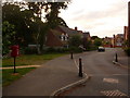
Ferndown: postbox № BH22 600, Casterbridge Road
This little postbox serves a very new housing development whose main thoroughfare, Casterbrigde Road, twists bewilderingly in several places. The box is emptied at 5pm on weekdays and at 9am on Saturdays.
Image: © Chris Downer
Taken: 15 Jun 2009
0.12 miles
2
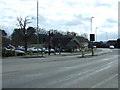
West Parley, footpath
The Southern end of a path from Christchurch Road to Image On the other side of Christchurch Road, Dudsbury Golf Club.
Image: © Mike Faherty
Taken: 31 Jul 2009
0.16 miles
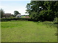
3
Tumulus, Casterbridge Road, Ferndown
This very flat tumulus was fenced off when the new housing estate was built.
Image: © Lorraine and Keith Bowdler
Taken: 27 Mar 2010
0.17 miles
4
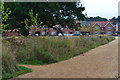
View toward new houses at Holmwood Park
Image: © David Martin
Taken: 14 Aug 2020
0.18 miles
5
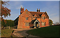
The former Hillamsland Farmhouse - Ferndown
This house is a mixture of C17 and C19 build - the left or west facing gabled block being the oldest part, the remainder being C19 'Tudor'. The former Hillamsland farmhouse is now a restaurant, a part of the Dudsbury Golf Course complex, whose entrance is alongside. It stands on the south side of Christchurch road, between Longham and Parley Cross. Grade II Listed.
Image: © Mike Searle
Taken: 12 Nov 2007
0.21 miles
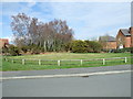
6
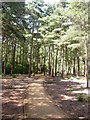
Poor Common, permissive bridleway
One of several well-maintained paths described on signposts as "permissive horse route".
Image: © Mike Faherty
Taken: 31 Jul 2009
0.23 miles
7
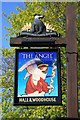
The sign for The Angel
With the Hall and Woodhouse badger motif above.
For long-shot see Image
Image: © David Lally
Taken: 18 Apr 2010
0.24 miles
9
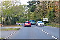
B3073 Christchurch Road
Towards Wimborne Minster.
Image: © Robin Webster
Taken: 3 Nov 2018
0.24 miles
10
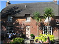
The Angel, Longham. Ferndown
Image: © Lorraine and Keith Bowdler
Taken: 27 Mar 2010
0.24 miles