IMAGES TAKEN NEAR TO
Gallows Drive, FERNDOWN, BH22 8RH
Introduction
This page details the photographs taken nearby to Gallows Drive, BH22 8RH by members of the Geograph project.
The Geograph project started in 2005 with the aim of publishing, organising and preserving representative images for every square kilometre of Great Britain, Ireland and the Isle of Man.

There are currently over 7.5m images from over14,400 individuals and you can help contribute to the project by visiting https://www.geograph.org.uk
Image Map
Images are licensed for reuse under creativecommons.org/licenses/by-sa/2.0
Notes
- Clicking on the map will re-center to the selected point.
- The higher the marker number, the further away the image location is from the centre of the postcode.
Image Listing (17 Images Found)
Images are licensed for reuse under creativecommons.org/licenses/by-sa/2.0
Image
Details
Distance
1
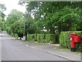
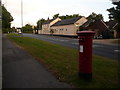
West Parley: postbox № BH22 176, Chine Walk
I'm sure I recall, about 25 years ago, the postbox here being a wall box set into a brick pillar. Either it has been replaced in recent years, or I'm getting it confused with Image a short distance away. But I wonder if that concrete square just to the left of the current box marks its former position.
Anyhow, it is an Elizabeth II-reign box and its advertised final collection times are 5:15pm on weekdays and noon on Saturdays.
Image: © Chris Downer
Taken: 9 Jun 2009
0.13 miles
2
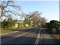
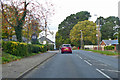
West Parley, Dudsbury Road
Tree-lined road connecting Christchurch and New Roads.
Image: © Mike Faherty
Taken: 31 Jul 2009
0.16 miles
3
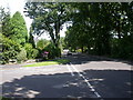
Road Junction, West Parley, Dorset
This is the junction between Linden Road and Dudsbury Road. The name Dudsbury comes from the nearby hillfort.
Image: © Stuart Buchan
Taken: 12 Dec 2005
0.17 miles
4
West Parley: postbox № BH22 19, Christchurch Road
From the West Parley point of view, Christchurch Road seems a bit of a misnomer on this western side of Parley Cross, since it's the road to Wimborne. This postbox, opposite the Horns Inn, is emptied finally at 5pm on weekdays and at noon on Saturdays.
Image: © Chris Downer
Taken: 15 Jun 2009
0.17 miles
5
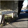
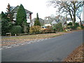
West Parley: Gallows Drive
Gallows Drive is at the very corner of the gridsquare and also at the very limit of my 2km radius from home. The sign here is a modern one with the logo of East Dorset District Council, which was absolved in the Local Government Reorganisation of April 2019 when Dorset became a unitary authority and the districts under it were abolished.
This is photo no.155 of a series of 453 in my coronavirus lockdown walking project:
See https://www.geograph.org.uk/article/My-2020-Coronavirus-Lockdown-walking-project for the complete set of photos.
Image: © Chris Downer
Taken: 15 Apr 2020
0.17 miles
7
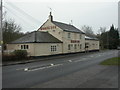
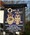
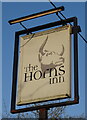
West Parley, Horns Inn
Internally, polygonal bar to right, drinking & eating areas at different levels to left; light wood & cream decor. Cask ales on offer at my visit: Adnam's Broadside, Morrissey & Fox Mulled Ale, Ringwood Best. For some customer reviews, see http://www.beerintheevening.com/pubs/s/28/2837/Horns/West_Parley
Image: © Mike Faherty
Taken: 8 Feb 2009
0.18 miles
9
B3073 Christchurch Road
Towards Wimborne Minster.
Image: © Robin Webster
Taken: 3 Nov 2018
0.18 miles