IMAGES TAKEN NEAR TO
Casterbridge Road, FERNDOWN, BH22 8LN
Introduction
This page details the photographs taken nearby to Casterbridge Road, BH22 8LN by members of the Geograph project.
The Geograph project started in 2005 with the aim of publishing, organising and preserving representative images for every square kilometre of Great Britain, Ireland and the Isle of Man.

There are currently over 7.5m images from over14,400 individuals and you can help contribute to the project by visiting https://www.geograph.org.uk
Image Map
Images are licensed for reuse under creativecommons.org/licenses/by-sa/2.0
Notes
- Clicking on the map will re-center to the selected point.
- The higher the marker number, the further away the image location is from the centre of the postcode.
Image Listing (5 Images Found)
Images are licensed for reuse under creativecommons.org/licenses/by-sa/2.0
Image
Details
Distance
1
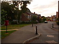
Ferndown: postbox № BH22 600, Casterbridge Road
This little postbox serves a very new housing development whose main thoroughfare, Casterbrigde Road, twists bewilderingly in several places. The box is emptied at 5pm on weekdays and at 9am on Saturdays.
Image: © Chris Downer
Taken: 15 Jun 2009
0.01 miles
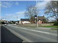
2
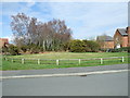
Tumulus, Casterbridge Road, Ferndown
This very flat tumulus was fenced off when the new housing estate was built.
Image: © Lorraine and Keith Bowdler
Taken: 27 Mar 2010
0.05 miles
3
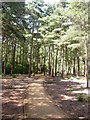
Poor Common, permissive bridleway
One of several well-maintained paths described on signposts as "permissive horse route".
Image: © Mike Faherty
Taken: 31 Jul 2009
0.21 miles
4
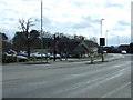
The Angel, Longham. Ferndown
Image: © Lorraine and Keith Bowdler
Taken: 27 Mar 2010
0.25 miles
5
The Angel, Longham, Ferndown
This part of The Angel was originally a cottage and outbuilding. Their conversion doubled the size of the pub.
Image: © Lorraine and Keith Bowdler
Taken: 27 Mar 2010
0.25 miles