IMAGES TAKEN NEAR TO
The Avenue, FERNDOWN, BH22 0LU
Introduction
This page details the photographs taken nearby to The Avenue, BH22 0LU by members of the Geograph project.
The Geograph project started in 2005 with the aim of publishing, organising and preserving representative images for every square kilometre of Great Britain, Ireland and the Isle of Man.

There are currently over 7.5m images from over14,400 individuals and you can help contribute to the project by visiting https://www.geograph.org.uk
Image Map
Images are licensed for reuse under creativecommons.org/licenses/by-sa/2.0
Notes
- Clicking on the map will re-center to the selected point.
- The higher the marker number, the further away the image location is from the centre of the postcode.
Image Listing (22 Images Found)
Images are licensed for reuse under creativecommons.org/licenses/by-sa/2.0
Image
Details
Distance
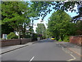
1
The Avenue West Moors
The Avenue is a leafy residential road consisting of substantial detached houses that leads west off the B3072 on the north side of the village.
Image: © Nigel Mykura
Taken: 28 Mar 2013
0.04 miles
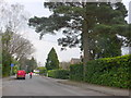
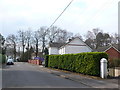
2
Ashurst Road
A narrow fairly leafy residential road in West Moors.
Image: © Bill Boaden
Taken: 6 Sep 2021
0.09 miles
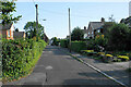
3
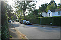
The Avenue
A leafy residential road in West Moors.
Image: © Bill Boaden
Taken: 6 Sep 2021
0.10 miles
4
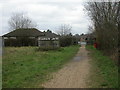
West Moors, old buffers
Concrete buffers at old sidings servicing the RAOC/Mod fuel depot; as seen looking towards Arnold Close. http://www.subbrit.org.uk/sb-sites/stations/w/west_moors/index.shtml
Image: © Mike Faherty
Taken: 31 Dec 2009
0.15 miles
5
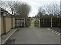
West Moors, stile
Squeezing stile at the western entrance of the Castleman Trailway, from West Moors to Ashley Heath; a permissive footpath, probably still in the possession of MoD.
Image: © Mike Faherty
Taken: 31 Dec 2009
0.15 miles
6
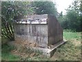
Old Railway buffers
Old concrete buffer stops remaining in place at West Moors.
Image: © Mat Tuck
Taken: 13 Jul 2014
0.15 miles
7
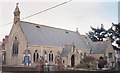
West Moors: parish church of St. Mary the Virgin
Built in the late 19th century.
Image: © Chris Downer
Taken: Unknown
0.17 miles
8
West Moors
This is Denewood road on the northern side of the village, consisting mainly of detached houses. Along with Ferndown it is the northernmost extent of the Bournemouth Conurbation.
Image: © Nigel Mykura
Taken: 28 Mar 2013
0.18 miles