
IMAGES TAKEN NEAR TO
Station Road, FERNDOWN, BH22 0HD
Introduction
This page details the photographs taken nearby to Station Road, BH22 0HD by members of the Geograph project.
The Geograph project started in 2005 with the aim of publishing, organising and preserving representative images for every square kilometre of Great Britain, Ireland and the Isle of Man.

There are currently over 7.5m images from over14,400 individuals and you can help contribute to the project by visiting https://www.geograph.org.uk
Image Map
Images are licensed for reuse under creativecommons.org/licenses/by-sa/2.0
Notes
- Clicking on the map will re-center to the selected point.
- The higher the marker number, the further away the image location is from the centre of the postcode.
Image Listing (37 Images Found)
Images are licensed for reuse under creativecommons.org/licenses/by-sa/2.0
Image
Details
Distance
1
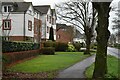
Retirement housing on Station Road, West Moors
Image: © David Martin
Taken: 10 Jan 2022
0.04 miles
2
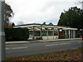
West Moors Library
On Station Road, at the junction with Moorlands Road. http://www.westmoorsdorset.co.uk/library_services.htm
Image: © Mike Faherty
Taken: 31 Dec 2009
0.05 miles
3
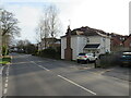
Station Road, West Moors
Station Road is the main road through the town of West Moors in Dorset. Its name is a clue that West Moors used to have a railway station. The house on the other side of the road is another clue that trains used to run here. It was built as a cottage to house the gatekeeper for the level crossing which was located here. The house was built at an angle to align with the railway tracks rather than the road. The railway closed to passengers in 1964, but remained open for occasional freight trains for a further ten years.
The road is on the route of the B3072.
Image: © Malc McDonald
Taken: 9 Mar 2025
0.06 miles
4
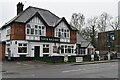
The Tap and Railway public house
Close to the site of the former railway station and level crossing at West Moors.
Image: © David Martin
Taken: 10 Jan 2022
0.07 miles
5
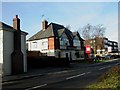
West Moors, Tap & Railway
Pub on Station Road. Internally, central curving bar, drinking and eating areas on three sides. Cask ales on offer at my visit: Ringwood Best, Fortyniner. For some customer comments, see http://www.beerintheevening.com/pubs/s/28/2885/Tap_Railway/West_Moors
Image: © Mike Faherty
Taken: 28 Dec 2009
0.07 miles
6
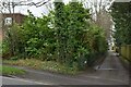
Site of West Moors level crossing and station
The former railway station occupied what is now this wooded patch beside Station Road. The railway route now forms part of the Castleman Trailway.
Image: © David Martin
Taken: 10 Jan 2022
0.07 miles
7
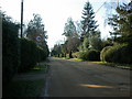
West Moors, Riverside Road
Private road from Station Road, stopping just short of Uddens Water. As the sign shows, not dog-friendly.
Image: © Mike Faherty
Taken: 2 Jan 2010
0.07 miles
8
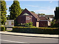
United Reformed Church - West Moors
This building (mostly) dates from the 1970s; a 'Congregational' church was built on this site in 1903 when West Moors was about to undergo its first (of many) spurts of development - later becoming part of the URC movement. The church lies centrally in the village, on the corner of Station Road and Moorlands Road here in West Moors. It is known formally as "St. Martin's, West Moors".
Image: © Martin Rowley
Taken: 12 Sep 2012
0.07 miles
9
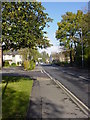
Station Road, West Moors, looking north
The white dwelling nearest the camera on the left-hand side of the road (Station Road) is the old Railway Crossing lodge - one of the earliest buildings extant in the village, which partially obscures the 'Tap and Railway' pub behind it - formerly the 'Railway Inn'. In the middle distance on the right stands the old Post Office and the still-trading Hardware/Pet food supply shop.
Image: © Martin Rowley
Taken: 4 Nov 2009
0.08 miles
10
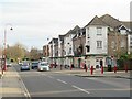
Station Road, West Moors
Station Road is the main road through the town of West Moors in Dorset. Its name is a clue that West Moors used to have a railway station. Trains no longer serve West Moors, as the station closed to passengers in 1964.
The road is on the route of the B3072.
Image: © Malc McDonald
Taken: 9 Mar 2025
0.09 miles