IMAGES TAKEN NEAR TO
Woodlands, WIMBORNE, BH21 8NG
Introduction
This page details the photographs taken nearby to BH21 8NG by members of the Geograph project.
The Geograph project started in 2005 with the aim of publishing, organising and preserving representative images for every square kilometre of Great Britain, Ireland and the Isle of Man.

There are currently over 7.5m images from over14,400 individuals and you can help contribute to the project by visiting https://www.geograph.org.uk
Image Map (Loading...)


Getting Data...Please wait
Leaflet Map data © OpenStreetMap
Images are licensed for reuse under creativecommons.org/licenses/by-sa/2.0
Notes
- Clicking on the map will re-center to the selected point.
- The higher the marker number, the further away the image location is from the centre of the postcode.
Image Listing (5 Images Found)
Images are licensed for reuse under creativecommons.org/licenses/by-sa/2.0
Image
Details
Distance
2
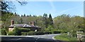
House and road junction at Remedy Gate
The place takes its name from the Remedy Oak Image On the right is the start of a footpath to Edmondsham, Image Image
Image: © David Smith
Taken: 3 May 2014
0.01 miles
3
Road Junction B3081
This is the road junction between the Woodlands road and the B3081.
Image: © Stuart Buchan
Taken: 26 Apr 2006
0.02 miles
4

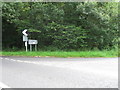
Sutton Holms: the Remedy Oak
Tradition has it that King Edward VI (the 'boy king') sat beneath this tree and touched those suffering from scurvy and suchlike (known as the King's Evil). Sufferers could supposedly be cured of King's Evil by being touched by a reigning monarch. This is mentioned, albeit in far fewer words, on a plaque beneath the tree.
Rather ironically, Edward VI died of tuberculosis at the age of 16.
Metal ropes can be seen to the left, stabilising the tree.
Image: © Chris Downer
Taken: 31 Aug 2008
0.02 miles
5

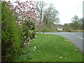
B3081 by Great Rough Copse
Trees just to the north of the road junction at Remedy Oak
Image: © David Smith
Taken: 3 May 2014
0.07 miles