IMAGES TAKEN NEAR TO
Uddens Trading Estate, WIMBORNE, BH21 7LE
Introduction
This page details the photographs taken nearby to Uddens Trading Estate, BH21 7LE by members of the Geograph project.
The Geograph project started in 2005 with the aim of publishing, organising and preserving representative images for every square kilometre of Great Britain, Ireland and the Isle of Man.

There are currently over 7.5m images from over14,400 individuals and you can help contribute to the project by visiting https://www.geograph.org.uk
Image Map (Loading...)


Getting Data...Please wait
Leaflet Map data © OpenStreetMap
Images are licensed for reuse under creativecommons.org/licenses/by-sa/2.0
Notes
- Clicking on the map will re-center to the selected point.
- The higher the marker number, the further away the image location is from the centre of the postcode.
Image Listing (11 Images Found)
Images are licensed for reuse under creativecommons.org/licenses/by-sa/2.0
Image
Details
Distance
1
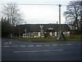
Stapehill, Old Thatch
Pub on Wimborne Road West. Thatch, single-storey with central dormer; central bar with open plan drinking & eating areas. Cask ales on offer at my visit: Fuller London Pride, Ringwood Forty Niner.
Image: © Mike Faherty
Taken: 19 Dec 2008
0.04 miles
2
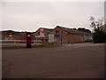
Stapehill: postbox № BH21 205, Uddens Trading Estate
This modern postbox serves the modestly sized Uddens Trading Estate, which shares its name with Uddens Drive onto which it comes out, and Uddens Water, a stream to the north of here.
Image: © Chris Downer
Taken: 12 Jun 2009
0.05 miles
3
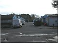
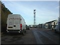
Stapehill, trading estate
Uddens Trading Estate, off Uddens Drive, with an diverse mix of electricity depot, garden, spice, dental, catering, shopfitting & paint stores, with a cafe.
Image: © Mike Faherty
Taken: 28 Nov 2009
0.08 miles
4
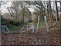
Stapehill, stile
Stile off Uddens Drive at the beginning of a bridleway to Colehill, partially following the course of the old Wimborne to Ringwood railway line.
Image: © Mike Faherty
Taken: 28 Nov 2009
0.10 miles
5
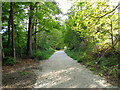
From Railway to Trailway
This trailway was once part of the double-track mainline running from London Waterloo to Weymouth. Bicycles are now the only wheeled vehicles you'll see along here nowadays.
Image: © Peter Kazmierczak
Taken: 13 May 2015
0.13 miles
6
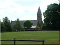
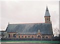
Stapehill Abbey near Wimborne
19th century building originally inhabited by Cistercian nuns, now a popular garden and crafts centre.
Image: © John Smitten
Taken: 15 Jul 2005
0.13 miles
7
Stapehill, mast
Telecom mast at the north-eastern corner of Uddens Trading Estate.
Image: © Mike Faherty
Taken: 28 Nov 2009
0.13 miles
8
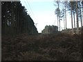
Stapehill, plantation
Part of the Forestry Commission's Uddens Plantation, detached from the main body by the A31 to the North.
Image: © Mike Faherty
Taken: 28 Nov 2009
0.14 miles
9
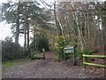
Stapehill, trails
At this point, two trails cross Uddens Drive: the Castleman Trailway, and the Ferndown, Stour & Forest Trail. The former roughly follows the route of the "Castleman Corkscrew" railway line, which was actually about 100m to the South.
Image: © Mike Faherty
Taken: 28 Nov 2009
0.15 miles
10
Former convent of Our Lady of Delours, Stapehill
This former convent opened in 1992 as a gardens, tea-room and small museum, but has recently (2006?) closed.
Image: © Chris Downer
Taken: Unknown
0.19 miles