IMAGES TAKEN NEAR TO
Uppington, Hinton Martell, WIMBORNE, BH21 7HA
Introduction
This page details the photographs taken nearby to BH21 7HA by members of the Geograph project.
The Geograph project started in 2005 with the aim of publishing, organising and preserving representative images for every square kilometre of Great Britain, Ireland and the Isle of Man.

There are currently over 7.5m images from over14,400 individuals and you can help contribute to the project by visiting https://www.geograph.org.uk
Image Map (Loading...)


Getting Data...Please wait
Leaflet Map data © OpenStreetMap
Images are licensed for reuse under creativecommons.org/licenses/by-sa/2.0
Notes
- Clicking on the map will re-center to the selected point.
- The higher the marker number, the further away the image location is from the centre of the postcode.
Image Listing (7 Images Found)
Images are licensed for reuse under creativecommons.org/licenses/by-sa/2.0
Image
Details
Distance
1
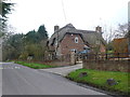
House in Uppington.
This is a very neat red-brick house with a very neat thatch on top of it. It would appear from the old bricks that it is an old house that has had a modern makeover.
Image: © Nigel Mykura
Taken: 28 Mar 2013
0.03 miles
2
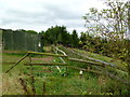
Uppington, stile
On the footpath from Chalbury to Piper's Hill, passing stables at Hill Farm.
Image: © Mike Faherty
Taken: 13 Aug 2011
0.18 miles
3
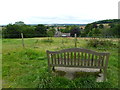
Hinton Martell, memorial seat
To Jim Singleton, 1956-2004, with a view towards Hinton Martell Church.
Image: © Mike Faherty
Taken: 13 Aug 2011
0.18 miles
4
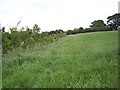
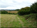
Field edge footpath near Hinton Martell
Footpath from Hinton Martell to Chalbury.
Image: © Maigheach-gheal
Taken: 13 Jun 2007
0.18 miles
5
Uppington, footpath
Along a recently cut silage field; the path runs from Chalbury to Piper's Hill.
Image: © Mike Faherty
Taken: 13 Aug 2011
0.21 miles
6
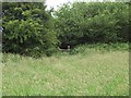
Stile in the hedge
The footpath crosses a grass field to the stile in the hedge on its way to Chalbury.
Image: © Maigheach-gheal
Taken: 13 Jun 2007
0.22 miles
7
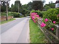
Road from Hinton Martell to Uppington
Image: © Maigheach-gheal
Taken: 13 Jun 2007
0.22 miles