IMAGES TAKEN NEAR TO
Colehill Lane, WIMBORNE, BH21 7AN
Introduction
This page details the photographs taken nearby to Colehill Lane, BH21 7AN by members of the Geograph project.
The Geograph project started in 2005 with the aim of publishing, organising and preserving representative images for every square kilometre of Great Britain, Ireland and the Isle of Man.

There are currently over 7.5m images from over14,400 individuals and you can help contribute to the project by visiting https://www.geograph.org.uk
Image Map
Images are licensed for reuse under creativecommons.org/licenses/by-sa/2.0
Notes
- Clicking on the map will re-center to the selected point.
- The higher the marker number, the further away the image location is from the centre of the postcode.
Image Listing (30 Images Found)
Images are licensed for reuse under creativecommons.org/licenses/by-sa/2.0
Image
Details
Distance
1
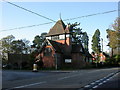
Colehill, parish church
At the junction of Smugglers & Long Lanes; built in 1893 in the Arts & Crafts style.
Image: © Mike Faherty
Taken: 3 Dec 2009
0.05 miles
4
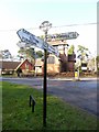
Old Direction Sign - Signpost by Colehill Lane, Colehill
Annulus and bar finial - 4 arms; Dorset halo with NGR by the UC road, in parish of Colehill (East Dorset District), on verge opposite Colehill Church, at crossroads junction of Colehill Lane with Smugglers' Lane - UC roads to Clapgate and Canford Bottom.
Surveyed
Milestone Society National ID: DO_SU0201A
Image: © Milestone Society
Taken: Unknown
0.07 miles
5
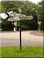
Colehill: finger-post at the church crossroads
One of numerous signposts which retain the original Dorset finial, giving location (Colehill Church in this case) and six-figure grid reference.
The fingers are, however, replacements; the originals would have been rounded rather than pointed, such as at the nearby Image
For a close-up of the finial, see Image
Image: © Chris Downer
Taken: 13 Jul 2009
0.07 miles
6
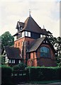
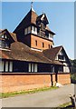
Colehill: parish church of St. Michael & All Angels
Designed in 1893 by Caroë.
Image: © Chris Downer
Taken: Unknown
0.07 miles
7
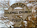
Colehill: detail of Colehill Church finger-post
A close-up of the finial of the finger-post (see Image), giving location and grid reference details.
Image: © Chris Downer
Taken: 7 Mar 2010
0.08 miles
8
Colehill Lane
Colehill Lane runs north from Colehill Five Ways to the village of Broomhill. On the left is St Michaels School. In the distance can be seen the church Of St Michaels and All Angels, a very beautiful Arts and Crafts designed church.
Image: © Nigel Mykura
Taken: 28 Mar 2013
0.09 miles
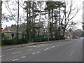
9
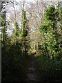
Colehill, bridleway
Bridleway through woodland from Smugglers Lane, near the parish church, to Cobb's Road and Long Lane.
Image: © Mike Faherty
Taken: 3 Dec 2009
0.10 miles
10
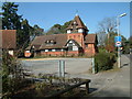
St. Michael's and All Angels' Church, Colehill, Dorset
This Church is on a busy junction in the centre of Colehill.
Image: © Stuart Buchan
Taken: 19 Mar 2006
0.10 miles