IMAGES TAKEN NEAR TO
Ringwood Road, WIMBORNE, BH21 6RA
Introduction
This page details the photographs taken nearby to Ringwood Road, BH21 6RA by members of the Geograph project.
The Geograph project started in 2005 with the aim of publishing, organising and preserving representative images for every square kilometre of Great Britain, Ireland and the Isle of Man.

There are currently over 7.5m images from over14,400 individuals and you can help contribute to the project by visiting https://www.geograph.org.uk
Image Map (Loading...)


Getting Data...Please wait
Leaflet Map data © OpenStreetMap
Images are licensed for reuse under creativecommons.org/licenses/by-sa/2.0
Notes
- Clicking on the map will re-center to the selected point.
- The higher the marker number, the further away the image location is from the centre of the postcode.
Image Listing (13 Images Found)
Images are licensed for reuse under creativecommons.org/licenses/by-sa/2.0
Image
Details
Distance
1
Wools Bridge
Almost unnoticed the River Moors passes quietly underneath.
Image: © Anthony Vosper
Taken: 22 Aug 2013
0.12 miles
2
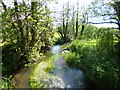
Woolsbridge, Moors River
Looking downstream from Wools Bridge. Further upstream, the river becomes River Crane.
Image: © Mike Faherty
Taken: 26 May 2012
0.12 miles
3
Entrance to Wools Bridge Manor caravan Park
A quiet secluded part of the New Forest.
Image: © Anthony Vosper
Taken: 22 Aug 2013
0.14 miles
4
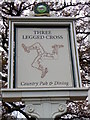
Sign for the Three Legged Cross
Not the place to live and fall foul of the law. This pub and village is named after the gallows, which were often nicknamed the three legged mare or three legged cross
Image: © Maigheach-gheal
Taken: 15 Dec 2010
0.15 miles
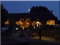
5
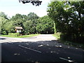
The Three Legged Cross Inn
Until recently the pub was known as the Old Barn Farm Inn. It is on the edge of an industrial estate. For a view of the sign Image
Image: © Maigheach-gheal
Taken: 15 Dec 2010
0.16 miles
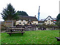
7
Woolsbridge: moon over the Old Barn Farm Inn
An attractive, thatched country pub in an almost incongruous setting alongside an out-of-town industrial estate. Smoker or not, it's been a beautiful evening to be sat outside.
Image: © Chris Downer
Taken: 3 Jul 2009
0.17 miles
8
Woolsbridge, Old Barn Farm
Pub on Verwood Road, shown on old maps as Woolsbridge Farm. Difficult to photograph as it is situated right at the Northern edge of this square. Externally, large car park, garden, pond & dovecote (visible at the back); internally, L-shaped bar, eating & drinking areas surrounding it; darts, low ceilings & wooden beams. For some customer reviews, http://www.beerintheevening.com/pubs/s/22/22130/Old_Barn_Farm/Three_Legged_Cross
Image: © Mike Faherty
Taken: 14 Aug 2009
0.17 miles
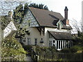
9
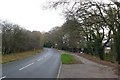
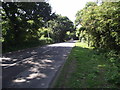
Woolsbridge Dorset
View west along the main road through Woolsbridge close to Lions Hill Farmhouse
Image: © Nigel Mykura
Taken: 26 Nov 2008
0.20 miles
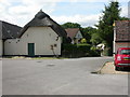
10
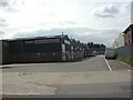
Woolsbridge, Crane Way
Woolsbridge Industrial Park comprises Old Barn Farm Road, with turnings off it called "Close" or "Way".
Image: © Mike Faherty
Taken: 8 Aug 2010
0.23 miles