IMAGES TAKEN NEAR TO
Hare Lane, WIMBORNE, BH21 5QT
Introduction
This page details the photographs taken nearby to Hare Lane, BH21 5QT by members of the Geograph project.
The Geograph project started in 2005 with the aim of publishing, organising and preserving representative images for every square kilometre of Great Britain, Ireland and the Isle of Man.

There are currently over 7.5m images from over14,400 individuals and you can help contribute to the project by visiting https://www.geograph.org.uk
Image Map
Images are licensed for reuse under creativecommons.org/licenses/by-sa/2.0
Notes
- Clicking on the map will re-center to the selected point.
- The higher the marker number, the further away the image location is from the centre of the postcode.
Image Listing (15 Images Found)
Images are licensed for reuse under creativecommons.org/licenses/by-sa/2.0
Image
Details
Distance
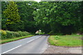
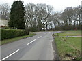
2

Cripplestyle Road Junction, Dorset
Cripplestyle is in the parish of Alderholt. Alderholt parish church only
dates from 1849 before which it was part of the larger parish of Cranborne.
Image: © Stuart Buchan
Taken: 5 Dec 2005
0.19 miles
3
Cripplestyle, Batterley Drove
From Cripplestyle to Gotham; not much livestock being driven today.
Image: © Mike Faherty
Taken: 20 Feb 2011
0.19 miles
4
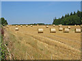
Straw bales
Small wheat field beside Alderholt to Cranborne Road.
Image: © Clive Perrin
Taken: 17 Jul 2006
0.19 miles
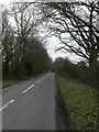
5
Cripplestyle Road junction from Hare Lane
Image: © John Firth
Taken: 13 Apr 2013
0.19 miles
6
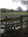
Cripplestyle, stile
On the footpath to Cripplestyle hamlet; the going ahead promises to be slippery.
Image: © Mike Faherty
Taken: 20 Feb 2011
0.19 miles
7
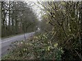
Cripplestyle, catkins
Harbingers of spring, on Batterley Drove.
Image: © Mike Faherty
Taken: 20 Feb 2011
0.20 miles
8
Cripplestyle, T-junction
Looking from Batterley Drove towards Cranborne Road (B3078).
Image: © Mike Faherty
Taken: 20 Feb 2011
0.20 miles
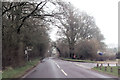
9
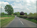
B3078 northwest of Hare Lane Farm
The farm in question gives the 'B' road its name: Hare Lane.
Image: © Stuart Logan
Taken: 4 Jun 2013
0.21 miles
10
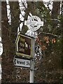
Direction Sign ? Signpost
Located on the north side of the B3078 Hare Lane, opposite Batterley Drove in Alderholt parish. 1 worboys arm and annulus & bar finial. See also https://www.geograph.org.uk/photo/1741237 and https://www.geograph.org.uk/photo/1741233.
Milestone Society National ID: DO_SU0812
Image: © S Brain
Taken: 12 Jan 2019
0.21 miles