IMAGES TAKEN NEAR TO
Castle Close, WIMBORNE, BH21 5QG
Introduction
This page details the photographs taken nearby to Castle Close, BH21 5QG by members of the Geograph project.
The Geograph project started in 2005 with the aim of publishing, organising and preserving representative images for every square kilometre of Great Britain, Ireland and the Isle of Man.

There are currently over 7.5m images from over14,400 individuals and you can help contribute to the project by visiting https://www.geograph.org.uk
Image Map (Loading...)


Getting Data...Please wait
Leaflet Map data © OpenStreetMap
Images are licensed for reuse under creativecommons.org/licenses/by-sa/2.0
Notes
- Clicking on the map will re-center to the selected point.
- The higher the marker number, the further away the image location is from the centre of the postcode.
Image Listing (87 Images Found)
Images are licensed for reuse under creativecommons.org/licenses/by-sa/2.0
Image
Details
Distance
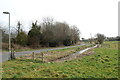
3
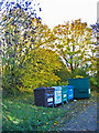
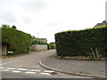
Recycling centre Cranborne Dorset
Just off Castle Street.
Image: © Clive Perrin
Taken: 18 Nov 2006
0.07 miles
4
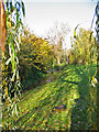
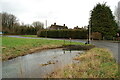
The River Crane Cranborne Dorset
A winterbourne now flowing.
Image: © Clive Perrin
Taken: 18 Nov 2006
0.09 miles
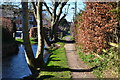
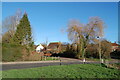
7
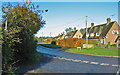
River Crane Cranborne
Occasionally floods the road here.
Image: © Clive Perrin
Taken: 11 Mar 2015
0.10 miles
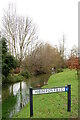
8
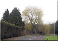
Willow and mole hills
The River Crane flows under the road here.
Image: © Clive Perrin
Taken: 9 Jan 2019
0.11 miles