IMAGES TAKEN NEAR TO
Castle Street, WIMBORNE, BH21 5PL
Introduction
This page details the photographs taken nearby to Castle Street, BH21 5PL by members of the Geograph project.
The Geograph project started in 2005 with the aim of publishing, organising and preserving representative images for every square kilometre of Great Britain, Ireland and the Isle of Man.

There are currently over 7.5m images from over14,400 individuals and you can help contribute to the project by visiting https://www.geograph.org.uk
Image Map (Loading...)


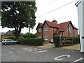
Getting Data...Please wait
Leaflet Map data © OpenStreetMap
Images are licensed for reuse under creativecommons.org/licenses/by-sa/2.0
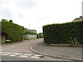
Notes
- Clicking on the map will re-center to the selected point.
- The higher the marker number, the further away the image location is from the centre of the postcode.
Image Listing (194 Images Found)
Images are licensed for reuse under creativecommons.org/licenses/by-sa/2.0
Image
Details
Distance
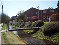
2
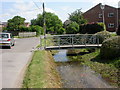
Cranborne, footbridges
Two footbridges over the River Crane, giving access from Water Street to houses on the other bank; in the foreground, concrete with steel balustrade, in the background, wood.
Image: © Mike Faherty
Taken: 31 May 2009
0.02 miles
4
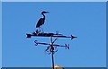
Weather vane, Cranborne
Weather vane of crane, beside the River Crane at Cranborne.
For centuries weather vanes have kept people in touch with the elements, signalling those shifts in the wind, which bring changes in the weather. Traditionally they often had a cockerel on top of the compass, but nowadays almost any shape can be used.
Image: © Maigheach-gheal
Taken: 26 Jan 2005
0.06 miles
6
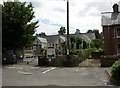
Cranborne, first school
Cranborne CE VA First School, on Water Street. http://www.cranbornefirst.dorset.sch.uk/
Image: © Mike Faherty
Taken: 31 Jul 2010
0.08 miles
7

Cranborne in 1985
The houses in the foreground are situated in Penny's Mead
Image: © John Baker
Taken: 30 Mar 1985
0.08 miles
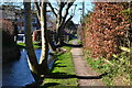
8
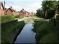
Cranborne, River Crane
In its upper reaches, the Crane is a winterbourne: almost dry or very feeble in the summer, flowing freely in the winter. Seen here looking downstream along Water Street. http://www.dorsetlife.co.uk/articles/ArticlesDetail.asp?ID=565
Image: © Mike Faherty
Taken: 31 May 2009
0.08 miles
10
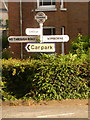
Cranborne: old finger-post
It is nice to see that quite a number of these old Dorset finger-posts survive intact with their original finial, giving location and grid reference. This one is marred ever so slightly by the modern (but not terribly recent) car park sign.
For a close-up of the finial, see Image
Image: © Chris Downer
Taken: 24 Jun 2009
0.09 miles