IMAGES TAKEN NEAR TO
Butts Close, WIMBORNE, BH21 5NB
Introduction
This page details the photographs taken nearby to Butts Close, BH21 5NB by members of the Geograph project.
The Geograph project started in 2005 with the aim of publishing, organising and preserving representative images for every square kilometre of Great Britain, Ireland and the Isle of Man.

There are currently over 7.5m images from over14,400 individuals and you can help contribute to the project by visiting https://www.geograph.org.uk
Image Map (Loading...)


Getting Data...Please wait
Leaflet Map data © OpenStreetMap
Images are licensed for reuse under creativecommons.org/licenses/by-sa/2.0
Notes
- Clicking on the map will re-center to the selected point.
- The higher the marker number, the further away the image location is from the centre of the postcode.
Image Listing (127 Images Found)
Images are licensed for reuse under creativecommons.org/licenses/by-sa/2.0
Image
Details
Distance
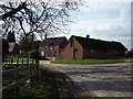
1
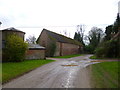
Wimborne St Giles, farm building
At Home Farm.
Image: © Mike Faherty
Taken: 8 Feb 2013
0.01 miles
2
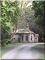
Lodge by the drive to St Giles House
Seen from the gates, using a bit of zoom. A curious little building, the overall layout informal and rustic, but the architectural detail latter-day Classical.
Image: © Stefan Czapski
Taken: 28 Apr 2011
0.05 miles
3
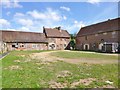
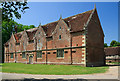
Wimborne St Giles, stable yard
For a view of the main building, see Image
Image: © Mike Faherty
Taken: 3 Aug 2013
0.05 miles
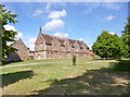
4
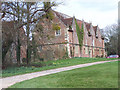
Stable yard, St Giles Park
The former stables and grooms' quarters are now redundant, although the park and garden buildings are grade II listed. The building to the left of the picture is the little cottage in which my parents lived when they were first married over half a century ago.
Image: © Maigheach-gheal
Taken: 16 Mar 2007
0.05 miles
5
St Giles House, Wimborne St Giles - stable block (7)
http://www.geograph.org.uk/photo/2965037
Image: © Mike Searle
Taken: 27 May 2012
0.07 miles
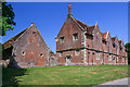
6
Wimborne St Giles, stable block
Overlooking Image; listed by English Heritage: http://www.imagesofengland.org.uk/Details/Default.aspx?id=107453&mode=adv
Image: © Mike Faherty
Taken: 3 Aug 2013
0.07 miles
7
St Giles House, Wimborne St Giles - stable block (6)
Red brick and Jacobean in style, the same date as the house, of the mid-C17. Grade II listed. http://www.geograph.org.uk/photo/2964999
Image: © Mike Searle
Taken: 27 May 2012
0.07 miles
8
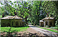
St Giles House, Wimborne St Giles - entrance lodges (8)
Like the house, these have now become derelict. http://www.geograph.org.uk/photo/2965066
Image: © Mike Searle
Taken: 27 May 2012
0.09 miles
9
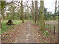
Wimborne St Giles, footpath
From the parish church to Manor Farm, skirting the grounds of St Giles House (to the right).
Image: © Mike Faherty
Taken: 8 Feb 2013
0.09 miles
10
Home Farm, St Giles Park, Wimborne St Giles
Image: © Maigheach-gheal
Taken: 16 Mar 2007
0.09 miles