IMAGES TAKEN NEAR TO
Gussage St. Michael, WIMBORNE, BH21 5JD
Introduction
This page details the photographs taken nearby to BH21 5JD by members of the Geograph project.
The Geograph project started in 2005 with the aim of publishing, organising and preserving representative images for every square kilometre of Great Britain, Ireland and the Isle of Man.

There are currently over 7.5m images from over14,400 individuals and you can help contribute to the project by visiting https://www.geograph.org.uk
Image Map (Loading...)


Getting Data...Please wait
Leaflet Map data © OpenStreetMap
Images are licensed for reuse under creativecommons.org/licenses/by-sa/2.0
Notes
- Clicking on the map will re-center to the selected point.
- The higher the marker number, the further away the image location is from the centre of the postcode.
Image Listing (51 Images Found)
Images are licensed for reuse under creativecommons.org/licenses/by-sa/2.0
Image
Details
Distance
2
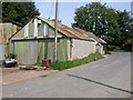
Gussage St Michael, engineers
The business of AG Edwards, with yards to the front & opposite; shown on old maps as "Smithy".
Image: © Mike Faherty
Taken: 8 Aug 2009
0.08 miles
3
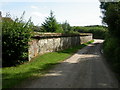
Gussage St Michael, cob wall
Cob wall in front of Lower Farm, with tiled coping and flint base. Cob structures were made of mud and whatever was available locally, in this case chalk. The wall has been patched up over the years with flints, bricks and breezeblocks.
Image: © Mike Faherty
Taken: 8 Aug 2009
0.09 miles
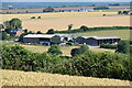
4
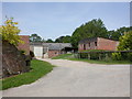
Gussage St Michael, farm buildings
At Lower Farm, North of the village.
Image: © Mike Faherty
Taken: 8 Aug 2009
0.10 miles
5
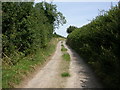
Gussage St Michael, byway
Byway (open to traffic) North from the village, becoming a bridleway and track in 500m.
Image: © Mike Faherty
Taken: 8 Aug 2009
0.11 miles
6
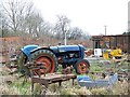
Scrapyard, Gussage St Michael
The name Gussage comes from the Anglo-Saxon "Gwysych", which means a bourne stream (Gwy = water; sych = dry. A stream which dries up).
There is a small scrapyard in the village. The tractor is a Fordson Major.
Image: © Maigheach-gheal
Taken: 31 Jan 2009
0.12 miles
7
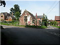
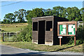
Gussage St Michael, village community hall
Formerly the village school, with fund raising in progress.
Image: © Mike Faherty
Taken: 8 Aug 2009
0.14 miles
8
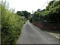
Gussage St Michael, Manor Road
Leading from the village centre to Manor Farm, with a mixture of old and new cottages.
Image: © Mike Faherty
Taken: 8 Aug 2009
0.14 miles
10
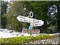
Old Direction Sign - Signpost in Gussage St Michael
Annulus finial - 3 arms; Dorset halo without National Grid Reference by the UC road, in parish and village of Gussage St Michael (East Dorset District), junction of UC road to Cashmoor, behind wall.
Surveyed
Milestone Society National ID: DO_ST9811A.
Image: © Milestone Society
Taken: Unknown
0.15 miles