IMAGES TAKEN NEAR TO
Witchampton Lane, WIMBORNE, BH21 5AF
Introduction
This page details the photographs taken nearby to Witchampton Lane, BH21 5AF by members of the Geograph project.
The Geograph project started in 2005 with the aim of publishing, organising and preserving representative images for every square kilometre of Great Britain, Ireland and the Isle of Man.

There are currently over 7.5m images from over14,400 individuals and you can help contribute to the project by visiting https://www.geograph.org.uk
Image Map
Images are licensed for reuse under creativecommons.org/licenses/by-sa/2.0
Notes
- Clicking on the map will re-center to the selected point.
- The higher the marker number, the further away the image location is from the centre of the postcode.
Image Listing (5 Images Found)
Images are licensed for reuse under creativecommons.org/licenses/by-sa/2.0
Image
Details
Distance
1
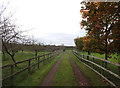
High Lea Dairy
An orchard and farm track alongside High Lea Dairy.
Image: © Peter Kazmierczak
Taken: 23 Oct 2015
0.03 miles
3
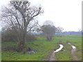
Muddy track of Witchampton Lane
This low lying land west of the village is on the flood plain of the River Allen and the fields are quite boggy.
Image: © Nigel Mykura
Taken: 28 Mar 2013
0.19 miles
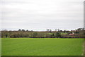
5
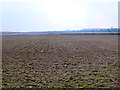
Fields near Witchampton
These fertile arable fields are on the floodplain of the Allen just south east of Witchampton. This is the view from Witchampton lane.
Image: © Nigel Mykura
Taken: 28 Mar 2013
0.25 miles