IMAGES TAKEN NEAR TO
Kings Street, WIMBORNE, BH21 4BN
Introduction
This page details the photographs taken nearby to Kings Street, BH21 4BN by members of the Geograph project.
The Geograph project started in 2005 with the aim of publishing, organising and preserving representative images for every square kilometre of Great Britain, Ireland and the Isle of Man.

There are currently over 7.5m images from over14,400 individuals and you can help contribute to the project by visiting https://www.geograph.org.uk
Image Map (Loading...)


Getting Data...Please wait
Leaflet Map data © OpenStreetMap
Images are licensed for reuse under creativecommons.org/licenses/by-sa/2.0
Notes
- Clicking on the map will re-center to the selected point.
- The higher the marker number, the further away the image location is from the centre of the postcode.
Image Listing (47 Images Found)
Images are licensed for reuse under creativecommons.org/licenses/by-sa/2.0
Image
Details
Distance
1
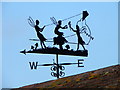
Weather vane, Sturminster Marshall
Weather vanes have always been more than just a wind direction device. Created by skilled craftsman, there is true artistic expression in the varied designs. Initially wood vanes were carved by carpenters or furniture makers, and iron, copper and tin ones were forged by the local blacksmith or tinsmith. In the 19th century weather vanes started to be mass-produced from moulds.
Image: © Maigheach-gheal
Taken: 25 Jun 2011
0.04 miles
2
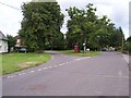
Sturminster Marshall
Greenspace and Telephone box in the centre of Sturminster Marshall
Image: © Steve Rigg
Taken: 14 Aug 2005
0.04 miles

4
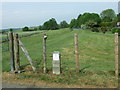
Flood Defences, Sturminster Marshall
This raised embankment was built in 1992, to protect Sturminster Marshall from flooding.
Image: © Lorraine and Keith Bowdler
Taken: 7 May 2011
0.06 miles
5
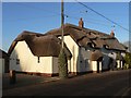
Sturminster Marshall: Juniper and Chapel Cottages
A very attractive pair of thatched cottages in King's Street, their eyebrow thatch doing funny things to the shadow of the telegraph pole.
Image: © Chris Downer
Taken: 7 Dec 2008
0.07 miles
6
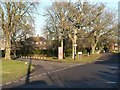
Sturminster Marshall: village green
Looking at the village green from its southwestern corner. King's Street is to the right (and behind camera) while Back Lane is to the left.
Image: © Chris Downer
Taken: 7 Dec 2008
0.09 miles

8
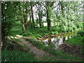
Footbridge over the River Winterborne, Sturminster Marshall
Image: © Lorraine and Keith Bowdler
Taken: 7 May 2011
0.10 miles
9
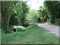
Bridges, Sturminster Marshall
Old footbridge and road bridge over the River Winterborne, on the track that leads to Millmoor Farm.
Image: © Lorraine and Keith Bowdler
Taken: 7 May 2011
0.10 miles
10
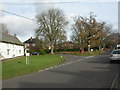
Village green, Sturminster Marshall
In front of the oak tree to the right of the phone box is a commemorative stone for the coronation of Edward VII; presumably the tree was planted then.
Image: © Mike Faherty
Taken: 21 Nov 2008
0.10 miles