IMAGES TAKEN NEAR TO
Poole Road, WIMBORNE, BH21 4AE
Introduction
This page details the photographs taken nearby to Poole Road, BH21 4AE by members of the Geograph project.
The Geograph project started in 2005 with the aim of publishing, organising and preserving representative images for every square kilometre of Great Britain, Ireland and the Isle of Man.

There are currently over 7.5m images from over14,400 individuals and you can help contribute to the project by visiting https://www.geograph.org.uk
Image Map
Images are licensed for reuse under creativecommons.org/licenses/by-sa/2.0
Notes
- Clicking on the map will re-center to the selected point.
- The higher the marker number, the further away the image location is from the centre of the postcode.
Image Listing (23 Images Found)
Images are licensed for reuse under creativecommons.org/licenses/by-sa/2.0
Image
Details
Distance
1
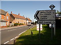
Sturminster Marshall: Bailie Cross signpost
Although the sign is a modern one, the finial has been retained from the original finger-post, which gives location details and also six-figure grid reference.
Beyond, we see modern housing on the site of what was once a petrol filling station.
Image: © Chris Downer
Taken: 27 Jun 2009
0.03 miles
2
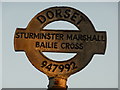
Sturminster Marshall: detail of Bailie Cross signpost
A close-up of the finial from the original finger-post, giving location and grid reference details, which has been retained and affixed to standard modern signage. See Image for the signpost as it looks now.
Image: © Chris Downer
Taken: 7 Mar 2010
0.03 miles
3
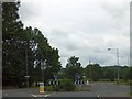
Bailie Cross roundabout
The A350 runs to the south of Sturminster Newton. This roundabout is where one of the main roads through the village joins the A350
Image: © David Smith
Taken: 23 Jun 2012
0.05 miles
5
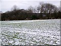
Arable field, Sturminster Marshall
The footpath crosses this arable field from Station Road.
Image: © Maigheach-gheal
Taken: 10 Jan 2010
0.07 miles
6
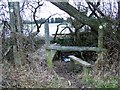
Double stile near Sturminster Marshall
The deep ditch is crossed by a plank bridge as the footpath continues to the A350.
Image: © Maigheach-gheal
Taken: 10 Jan 2010
0.07 miles
7
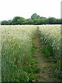
Footpath, Sturminster Marshall
The footpath heads through a crop of barley as it takes walkers from Station Road to the A350.
Image: © Maigheach-gheal
Taken: 25 Jun 2011
0.10 miles
8
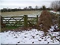
Stile, Sturminster Marshall
The broken stile brings walkers out on to the A350.
Image: © Maigheach-gheal
Taken: 10 Jan 2010
0.10 miles
9
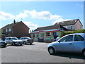
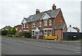
Spar Shop , Sturminster Marshall
This small shop in the middle of the village is tacked onto a much older house set further back from the road and now almost completely hidden by the shop. The shop has its own parking spaces just in front of it.It also houses the post office. It is on Station Rd which at its northern end becomes High St and at its southern end at the A350 becomes Dullar Lane.
Image: © Nigel Mykura
Taken: 8 May 2012
0.11 miles
10
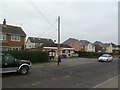
Sturminster Marshall Post Office
Post office and store, on Station Road.
Image: © Mike Faherty
Taken: 17 Jan 2012
0.11 miles