IMAGES TAKEN NEAR TO
Rushall Lane, WIMBORNE, BH21 3RS
Introduction
This page details the photographs taken nearby to Rushall Lane, BH21 3RS by members of the Geograph project.
The Geograph project started in 2005 with the aim of publishing, organising and preserving representative images for every square kilometre of Great Britain, Ireland and the Isle of Man.

There are currently over 7.5m images from over14,400 individuals and you can help contribute to the project by visiting https://www.geograph.org.uk
Image Map
Images are licensed for reuse under creativecommons.org/licenses/by-sa/2.0
Notes
- Clicking on the map will re-center to the selected point.
- The higher the marker number, the further away the image location is from the centre of the postcode.
Image Listing (5 Images Found)
Images are licensed for reuse under creativecommons.org/licenses/by-sa/2.0
Image
Details
Distance
1
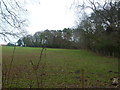
Corfe Mullen, Cherrett's Clump
Conifers on the skyline above Rushall Lane; also screening a disused sand pit.
Image: © Mike Faherty
Taken: 8 Jan 2012
0.04 miles
2
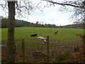
Corfe Mullen, paddocks
Off Rushall Lane. Most land use in this square seems to be horse-based.
Image: © Mike Faherty
Taken: 8 Jan 2012
0.13 miles
4
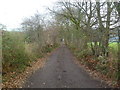
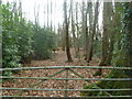
Corfe Mullen, bridleway
From Rushall Lane to Waterloo Road; also giving access to properties alongside.
Image: © Mike Faherty
Taken: 8 Jan 2012
0.21 miles
5
Corfe Mullen, Broom Copse
Oak and invasive Rhododendron ponticum, off Rushall Lane.
Image: © Mike Faherty
Taken: 8 Jan 2012
0.24 miles