IMAGES TAKEN NEAR TO
Arrowsmith Road, WIMBORNE, BH21 3BE
Introduction
This page details the photographs taken nearby to Arrowsmith Road, BH21 3BE by members of the Geograph project.
The Geograph project started in 2005 with the aim of publishing, organising and preserving representative images for every square kilometre of Great Britain, Ireland and the Isle of Man.

There are currently over 7.5m images from over14,400 individuals and you can help contribute to the project by visiting https://www.geograph.org.uk
Image Map
Images are licensed for reuse under creativecommons.org/licenses/by-sa/2.0
Notes
- Clicking on the map will re-center to the selected point.
- The higher the marker number, the further away the image location is from the centre of the postcode.
Image Listing (3 Images Found)
Images are licensed for reuse under creativecommons.org/licenses/by-sa/2.0
Image
Details
Distance
1
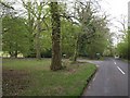
Junction, Brake Hills
A junction on Arrowsmith Road where a bridleway leaves on the left along the northern edge of Canford Heath, passing some large properties.
Image: © Derek Harper
Taken: 28 Apr 2010
0.14 miles
2
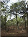
On Canford Heath
A little further west-south-west along the bridleway shown in Image, with the trees opening out a little, and pines giving way to birch.
Image: © Derek Harper
Taken: 28 Apr 2010
0.21 miles
3
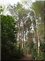
Trees on Canford Heath
Looking along a bridleway that crosses the northwest side of the heath, as it climbs among pines and other trees just northwest of the gravel pit.
Image: © Derek Harper
Taken: 28 Apr 2010
0.23 miles