IMAGES TAKEN NEAR TO
Canford Magna, WIMBORNE, BH21 3AE
Introduction
This page details the photographs taken nearby to BH21 3AE by members of the Geograph project.
The Geograph project started in 2005 with the aim of publishing, organising and preserving representative images for every square kilometre of Great Britain, Ireland and the Isle of Man.

There are currently over 7.5m images from over14,400 individuals and you can help contribute to the project by visiting https://www.geograph.org.uk
Image Map
Images are licensed for reuse under creativecommons.org/licenses/by-sa/2.0
Notes
- Clicking on the map will re-center to the selected point.
- The higher the marker number, the further away the image location is from the centre of the postcode.
Image Listing (20 Images Found)
Images are licensed for reuse under creativecommons.org/licenses/by-sa/2.0
Image
Details
Distance
1
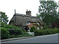
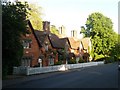
Thatched Cottage, Canford Magna
Image: © Lorraine and Keith Bowdler
Taken: 29 May 2011
0.03 miles
2
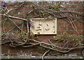
Number panel, Lady Wimborne Cottages
See Image; number 50 is the right-hand of the five cottages, but, as http://www.imagesofengland.org.uk/Details/Default.aspx?id=412428&mode=adv explains, the "terracotta panels have Gothic numbering from 50 to 54, part of a sequence covering the estate houses of the Wimborne estate", because the street number of this house is 15.
Image: © Derek Harper
Taken: 28 Apr 2010
0.05 miles
3
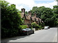
Canford Magna, Lady Wimborne Cottages
Former estate cottages on the western side of Canford Magna (the road, not the area); built for estate workers in the mid to late C19 and early C20. About 110 remain. They are built in a distinctive style, which includes plaques with date and family coat of arms, and are individually sequentially numbered. Numbers do not relate to Post Office or local authority numbers. These are cottages nos 45-49; in the middle is the village's old post office, no 47. Listed by English Heritage, http://www.imagesofengland.org.uk/Details/Default.aspx?id=412429&mode=quick
Image: © Mike Faherty
Taken: 12 Jun 2010
0.06 miles
4
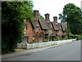
Canford Magna, Lady Wimborne Cottages
Former estate cottages on the eastern side of Canford Magna (the road, not the area); built for estate workers in the mid to late C19 and early C20. About 110 remain. They are built in a distinctive style, which includes plaques with date and family coat of arms, and are individually sequentially numbered. Numbers do not relate to Post Office or local authority numbers. These are cottages nos 50-54. Listed by English Heritage, http://www.imagesofengland.org.uk/Details/Default.aspx?id=412428&mode=quick
Image: © Mike Faherty
Taken: 12 Jun 2010
0.06 miles
5
Canford Magna: ?Lady Wimborne? cottages
A fine row of Victorian cottages, known locally as Lady Wimborne cottages after the owner of the Canford estate and much of the surrounding land at the time that they were built.
They are therefore dotted all around the area – for example, see Image
Image: © Chris Downer
Taken: 28 May 2009
0.06 miles
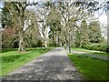
6
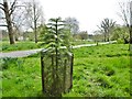
Canford Park, Wollemi Pine
A young specimen of Wollemia nobilis. The species was discovered in 1994; less than 100 exist in the wild, in Australia: http://en.wikipedia.org/wiki/Wollemia http://www.wollemipine.co.uk/acatalog/InterestingFeatures.html
Image: © Mike Faherty
Taken: 16 Apr 2015
0.07 miles
7
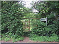
Footpath, Canford Magna
At first glance this looks like a fence but it is a gateway on the footpath FP No 29 to Bearwood. See Image for a view of the other side
Image: © Lorraine and Keith Bowdler
Taken: 29 May 2011
0.10 miles
8
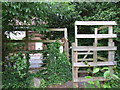
Footpath, Canford Magna
The other side of our previous photo Image, this gateway is on the Stour Valley Way.
Image: © Lorraine and Keith Bowdler
Taken: 29 May 2011
0.10 miles
10
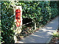
Canford Magna: postbox № BH21 73
A George VI-reign postbox set into a brick pillar.
Image: © Chris Downer
Taken: 21 Sep 2008
0.16 miles