IMAGES TAKEN NEAR TO
Cobbs Road, WIMBORNE, BH21 2RL
Introduction
This page details the photographs taken nearby to Cobbs Road, BH21 2RL by members of the Geograph project.
The Geograph project started in 2005 with the aim of publishing, organising and preserving representative images for every square kilometre of Great Britain, Ireland and the Isle of Man.

There are currently over 7.5m images from over14,400 individuals and you can help contribute to the project by visiting https://www.geograph.org.uk
Image Map
Images are licensed for reuse under creativecommons.org/licenses/by-sa/2.0
Notes
- Clicking on the map will re-center to the selected point.
- The higher the marker number, the further away the image location is from the centre of the postcode.
Image Listing (35 Images Found)
Images are licensed for reuse under creativecommons.org/licenses/by-sa/2.0
Image
Details
Distance
1
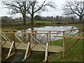
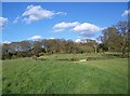
Colehill, pond
On the site of Poole & Wimborne Woodland Burial Ground http://www.woodlandburialground.co.uk/Our-Burial-Grounds/Poole-Wimborne/
Image: © Mike Faherty
Taken: 12 Feb 2012
0.10 miles
2

Colehill, burial ground
Poole & Wimborne Burial Ground, off Greenhill Road; the markers are memorials. http://www.woodlandburialground.co.uk/Our-Burial-Grounds/Poole-Wimborne/
Image: © Mike Faherty
Taken: 12 Feb 2012
0.14 miles
4
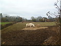
Colehill, horse grazing
Off Burt's Hill.
Image: © Mike Faherty
Taken: 12 Feb 2012
0.15 miles
5
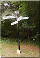
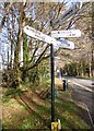
Colehill: Fiveways finger-post
A good example of a traditional Dorset signpost, with original rounded fingers (modern replacements tend to be pointed) and – rarer – the finial giving location and grid reference.
For a close-up of the finial, see Image
Image: © Chris Downer
Taken: 13 Jul 2009
0.17 miles
6
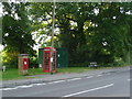
Colehill: postbox № BH21 32 and phone, Wimborne Road
A George V-reign postbox set into a brick pillar, alongside a traditional red phone box. The postbox is emptied finally at 5pm on weekdays and at noon on Saturdays.
Image: © Chris Downer
Taken: 24 Jun 2009
0.17 miles
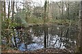
7
Poole and Wimborne Woodland Burial Ground
Image: © Maigheach-gheal
Taken: 11 Apr 2008
0.18 miles
8
Direction Sign - Signpost in Colehill
Annulus and bar finial - 5 arms; Dorset halo with NGR by the UC road, in parish of Colehill (East Dorset District), Colehill, Fiveways, junction of UC roads to Broom Hill and Wimborne, on verge.
Surveyed
Milestone Society National ID: DO_SU0200
Image: © Milestone Society
Taken: Unknown
0.18 miles
9
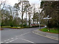
Colehill Five Ways
The old fashioned signpost at this junction includes the directions and the name of the junction and its grid reference to six figures. Dropped kerbs have been introduced to enable crossing of the main road (Wimborne to Colehill) but not to enable crossing of the minor roads.
Image: © Nigel Mykura
Taken: 28 Mar 2013
0.18 miles
10
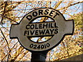
Colehill: Fiveways finger-post detail
A close-up of the finial of the finger-post (see Image), giving location and grid reference details.
Image: © Chris Downer
Taken: 7 Mar 2010
0.18 miles