IMAGES TAKEN NEAR TO
Leigh Road, WIMBORNE, BH21 2BU
Introduction
This page details the photographs taken nearby to Leigh Road, BH21 2BU by members of the Geograph project.
The Geograph project started in 2005 with the aim of publishing, organising and preserving representative images for every square kilometre of Great Britain, Ireland and the Isle of Man.

There are currently over 7.5m images from over14,400 individuals and you can help contribute to the project by visiting https://www.geograph.org.uk
Image Map
Images are licensed for reuse under creativecommons.org/licenses/by-sa/2.0
Notes
- Clicking on the map will re-center to the selected point.
- The higher the marker number, the further away the image location is from the centre of the postcode.
Image Listing (18 Images Found)
Images are licensed for reuse under creativecommons.org/licenses/by-sa/2.0
Image
Details
Distance
3
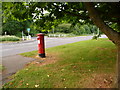
Colehill: postbox № BH21 10, Leigh Road
This postbox stands under the foliage of a tree on a grassy patch between Leigh and Brookside Roads, virtually on the boundary between Colehill parish and Wimborne Minster town. Its final collection occurs at 5:30pm on weekdays and at 11:30am on Saturdays.
Image: © Chris Downer
Taken: 10 Jun 2009
0.07 miles
4
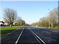
Northleigh Lane
The bridge over the old Southampton & Dorchester Railway on Northleigh Lane, saw its last passenger trains in 1964 and freight in 1974.
Image: © Peter Kazmierczak
Taken: 7 Mar 2016
0.10 miles
5
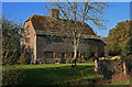
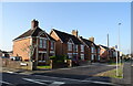
Old Manor Farmhouse - Wimborne
The county of Dorset is always full of surprises. It might be difficult to imagine that this old farmhouse is set almost in the heart of Wimborne's town centre, and adjacent to a small industrial estate, but it's a fact! The house has its origins in the C16, when it was built as a moated house. A portion of the moat still survives, part of which can be seen in the foreground, in front of the garden wall. During the C17 the house was partly rebuilt, and enlarged in the C18 and C19. The construction is an early example of local brickwork with stone detailing. The unseen north gable is timber framed. Grade II* Listed.
Image: © Mike Searle
Taken: 15 Nov 2007
0.11 miles
6
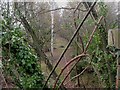
Leigh, dismantled railway
The trackbed of the "Castleman Corkscrew" (Southampton to Dorchester Railway), as seen from the roadbridge on Northleigh Lane. http://homepage.ntlworld.com/ron.strutt/rrcor2.html
Image: © Mike Faherty
Taken: 13 Dec 2009
0.11 miles
7
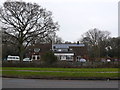
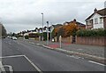
Day Nursery
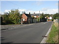
This building standing on its own on the north side of Leigh Rd on Leigh Common looks as if it might have been a pub at one time but it is now occupied by Tops Day Nursery.
Image: © Nigel Mykura
Taken: 6 Mar 2013
0.13 miles
8
Wimborne, pumping station
Sewage pumping station, at the junction of Brook and Livingstone Roads.
Image: © Mike Faherty
Taken: 25 Oct 2009
0.14 miles
9
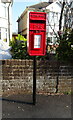
Elizabeth II postbox on Leigh Road
Postbox No. BH21 98.
Image: © JThomas
Taken: 23 Mar 2022
0.14 miles