IMAGES TAKEN NEAR TO
Sopwith Crescent, WIMBORNE, BH21 1XJ
Introduction
This page details the photographs taken nearby to Sopwith Crescent, BH21 1XJ by members of the Geograph project.
The Geograph project started in 2005 with the aim of publishing, organising and preserving representative images for every square kilometre of Great Britain, Ireland and the Isle of Man.

There are currently over 7.5m images from over14,400 individuals and you can help contribute to the project by visiting https://www.geograph.org.uk
Image Map
Images are licensed for reuse under creativecommons.org/licenses/by-sa/2.0
Notes
- Clicking on the map will re-center to the selected point.
- The higher the marker number, the further away the image location is from the centre of the postcode.
Image Listing (12 Images Found)
Images are licensed for reuse under creativecommons.org/licenses/by-sa/2.0
Image
Details
Distance
2
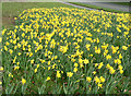
Daffodils in Merley
A bank of daffodils at the junction of Merley Lane and Queen Anne Drive.
Image: © Peter Kazmierczak
Taken: 15 Mar 2009
0.13 miles
3
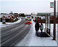
St Peter's School Bus
St Peter's school bus arrives at the stop at the junction of Sopwith Crescent and Brabazon Road, on a snowy morning.
Image: © Peter Kazmierczak
Taken: 4 Feb 2009
0.13 miles
4
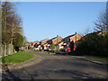
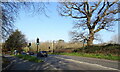
Junction of Queen Anne Drive and Merley Lane, Merley
Image: © Lorraine and Keith Bowdler
Taken: 3 Apr 2010
0.14 miles
5
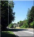
Queen Anne Drive, Merley
Queen Anne Drive, part of the A341, runs round the southern edge of Merley.
Image: © Peter Kazmierczak
Taken: 23 May 2010
0.16 miles
6
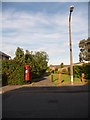
Merley: postbox № BH21 187, Chichester Walk
This Elizabeth II-reign postbox serves the eastern part of this fairly cast housing estate, and is emptied at 5:15pm on weekdays and at 11:30am on Saturdays, the Saturday time apparently a recent change since it is displayed on a sticker over the previous time.
Beyond, we look down a footpath to one of the 'arms' of Sopwith Crescent.
Image: © Chris Downer
Taken: 10 Jun 2009
0.20 miles
7
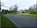
Merley, medical centre
Magna House Medical Centre, off Merley Lane.
Image: © Mike Faherty
Taken: 25 Apr 2011
0.23 miles

10
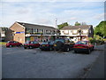
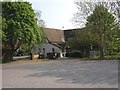
Merley: Oakley Shopping Centre
The shopping facilities of Merley, comprising a general store/post office on the left wing and a pharmacy (which used to be the post office), butcher's and Chinese takeaway on the right. There are flats above.
Image: © Chris Downer
Taken: 10 Jun 2009
0.25 miles