IMAGES TAKEN NEAR TO
Allenview Road, WIMBORNE, BH21 1UP
Introduction
This page details the photographs taken nearby to Allenview Road, BH21 1UP by members of the Geograph project.
The Geograph project started in 2005 with the aim of publishing, organising and preserving representative images for every square kilometre of Great Britain, Ireland and the Isle of Man.

There are currently over 7.5m images from over14,400 individuals and you can help contribute to the project by visiting https://www.geograph.org.uk
Image Map (Loading...)


Getting Data...Please wait
Leaflet Map data © OpenStreetMap
Images are licensed for reuse under creativecommons.org/licenses/by-sa/2.0
Notes
- Clicking on the map will re-center to the selected point.
- The higher the marker number, the further away the image location is from the centre of the postcode.
Image Listing (110 Images Found)
Images are licensed for reuse under creativecommons.org/licenses/by-sa/2.0
Image
Details
Distance
1
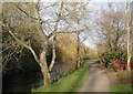
Wimborne, riverside walk
Footpath along the River Allen, from Hanham Road to Walford Mill.
Image: © Mike Faherty
Taken: 13 Dec 2009
0.04 miles
2
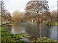
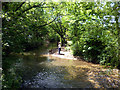
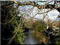
Wimborne, River Allen
Slightly swollen Allen, after recent rain. The Allen is a chalk stream tributary of the Stour, into which it flows just over 1km to the South. The river flows for about 20km, with its source near Wimborne St. Giles Image, to the North. As seen looking upstream.
Image: © Mike Faherty
Taken: 13 Dec 2009
0.04 miles
3
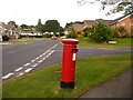
Wimborne Minster: postbox № BH21 4, Lacy Drive
This postbox serves a large-ish estate of bungalows – as is so often the case, few with even the smallest boundary wall or hedge – on the corner of Minster View. I didn't venture up there but there may well be a view towards the two towers of the minster.
The box is emptied finally at 5pm on weekdays and at noon on Saturdays.
Image: © Chris Downer
Taken: 10 Jun 2009
0.10 miles
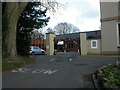
4
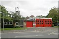
Wimborne Fire Station
Wimborne Fire Station, Allenview Road, Wimborne, Dorset.
Image: © Kevin Hale
Taken: 27 Sep 2006
0.11 miles
5
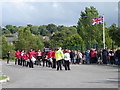
Dorset Youth Marching Band
The band are waiting to lead the local Beavers, Cubs, Scouts and Venture Scouts form Allanbourn Middle School to the Minster Church for a service to celebrate 25 years of Beaver Scouting.
Image: © Maigheach-gheal
Taken: 25 Sep 2011
0.11 miles
6
The River Allen
The Allen flows through the middle of town via a mostly green and tree lined route. Compared with many urban watercourses it has been treated well.
Image: © Des Blenkinsopp
Taken: 9 Jun 2013
0.11 miles
7
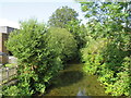
River Allen, Wimborne Minster
The River Allen flanked by greenery as it approaches the centre of Wimborne Minster.
Image: © Malc McDonald
Taken: 21 Aug 2021
0.11 miles
8
Wimborne, community centre
Allendale Community Centre, off Hanham Road, built in what was probably once the grounds of neighbouring Allendale House. http://www.idorset.co.uk/profile/106503/Wimborne/Allendale-Community-Centre/
Image: © Mike Faherty
Taken: 13 Dec 2009
0.11 miles
9
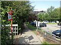
Wimborne, footbridge
One of several footbridges across River Allen, on the riverside walk. To the right, Allendale carpark. As seen from Hanham Road.
Image: © Mike Faherty
Taken: 13 Dec 2009
0.11 miles
10
Footpath and car park, Wimborne
A footpath and car park in the town of Wimborne Minster.
Image: © Malc McDonald
Taken: 21 Aug 2021
0.11 miles