IMAGES TAKEN NEAR TO
Oakley Lane, WIMBORNE, BH21 1SG
Introduction
This page details the photographs taken nearby to Oakley Lane, BH21 1SG by members of the Geograph project.
The Geograph project started in 2005 with the aim of publishing, organising and preserving representative images for every square kilometre of Great Britain, Ireland and the Isle of Man.

There are currently over 7.5m images from over14,400 individuals and you can help contribute to the project by visiting https://www.geograph.org.uk
Image Map
Images are licensed for reuse under creativecommons.org/licenses/by-sa/2.0
Notes
- Clicking on the map will re-center to the selected point.
- The higher the marker number, the further away the image location is from the centre of the postcode.
Image Listing (19 Images Found)
Images are licensed for reuse under creativecommons.org/licenses/by-sa/2.0
Image
Details
Distance
4
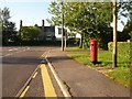
Merley: postbox № BH21 34, Oakley Straight
An Elizabeth II-reign postbox at the northern end of Oakley Straight; it is emptied finally at 5:15pm on weekdays and at 11:30am on Saturdays.
Image: © Chris Downer
Taken: 28 May 2009
0.06 miles
5
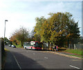
The Wimborne Flyer
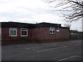
The Wimborne Flyer bus route links Poole with Wimborne; buses running alternatively via Corfe Mullen or, as illustrated here, Merley. Wilts & Dorset bus no.162 draws to a halt at the stop outside Merley First School.
Image: © Peter Kazmierczak
Taken: 26 Oct 2009
0.10 miles
7
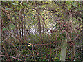
Here be trains (once upon a time)
Not a very inspiring picture; a chain-link fence with a single-carriageway road glimpsed beyond. However, I'm standing on the formation of the old Southampton & Dorchester Railway where it was carved through by the A31 Wimborne by-pass. Almost impossible to think this was once the trunk rail line linking London with Dorset.
Image: © Peter Kazmierczak
Taken: 26 Oct 2009
0.14 miles
8
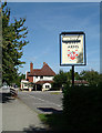
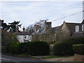
The Willett Arms
The Willett Arms public house and restaurant situated at the top of Oakley Hill. A view from the footpath leading to the Castleman Trail.
Image: © Peter Kazmierczak
Taken: 12 Sep 2009
0.15 miles
9
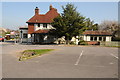
The Willets Arms, Oakley
The Willets Arms, Oakley, viewed from its car park.
Image: © Philip Halling
Taken: 17 Apr 2014
0.16 miles
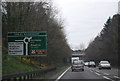
10
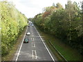
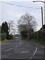
Wimborne Minster By-Pass
A31, as seen from the overbridge on Oakley Hill.
Image: © Mike Faherty
Taken: 25 Oct 2009
0.18 miles