
IMAGES TAKEN NEAR TO
Wimborne Road, WIMBORNE, BH21 1NN
Introduction
This page details the photographs taken nearby to Wimborne Road, BH21 1NN by members of the Geograph project.
The Geograph project started in 2005 with the aim of publishing, organising and preserving representative images for every square kilometre of Great Britain, Ireland and the Isle of Man.

There are currently over 7.5m images from over14,400 individuals and you can help contribute to the project by visiting https://www.geograph.org.uk
Image Map
Images are licensed for reuse under creativecommons.org/licenses/by-sa/2.0
Notes
- Clicking on the map will re-center to the selected point.
- The higher the marker number, the further away the image location is from the centre of the postcode.
Image Listing (37 Images Found)
Images are licensed for reuse under creativecommons.org/licenses/by-sa/2.0
Image
Details
Distance
1
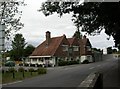
Wimborne, The Crown & Anchor
Pub on Wimborne Road, Walford, next to Image Internally, L-shaped bar, with eating and drinking areas to left and front, darts; outside seating overlooking River Allen. Cask ales on offer at my visit: Hall & Woodhouse Badger, Tanglefoot. For some customer comments, see http://www.beerintheevening.com/pubs/s/38/3838/Crown_and_Anchor/Wimborne
Image: © Mike Faherty
Taken: 31 Jul 2010
0.01 miles
2
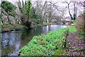
River Allen and Walford Bridge, Wimborne
View from close to the old mill now a craft centre. The bridge is an old pack horse bridge that was remodelled in 1802 to the designs of William Evans of Wimborne
Image: © Nigel Mykura
Taken: 26 Nov 2008
0.01 miles
3
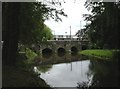
Wimborne, Walford Bridge
Stone bridge over River Allen on Wimborne Road, Walford.
Image: © Mike Faherty
Taken: 31 Jul 2010
0.03 miles
4
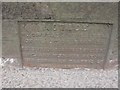
Old Bridge Marker by the B3078, Walford Bridge, Wimborne Minster
Bridge Weight Plate by the B3078, in parish of Wimborne Minster (East Dorset District), Walford Bridge, on East parapet, mid bridge, visible from road or by leaning over parapet from footpath. Partly buried in tarmac.
Inscription reads:-
NOTICE
TO OWNERS AND DRIVERS
OF TRACTION ENGINES
THIS BRIDGE IS INSUFFICIENT
TO CARRY WEIGHTS BEYOND
THE ORDINARY TRAFFIC OF
THE DISTRICT
Walford Bridge is Grade II* listed.
List Entry Number: 1119538 https://historicengland.org.uk/listing/the-list/list-entry/1119538
Surveyed
Milestone Society National ID: DO_WEIWIWabr
Image: © M Faherty
Taken: 11 Apr 2007
0.03 miles
5
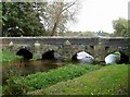
Bridge over the River Allen, Walford
There is a large patch of watercress by the riverbank.
Image: © Rose and Trev Clough
Taken: 16 Oct 2007
0.03 miles
6
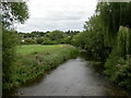
Wimborne, River Allen
As seen from Image; the river joins the Stour about 1500m to the South-east.
Image: © Mike Faherty
Taken: 31 Jul 2010
0.03 miles
7
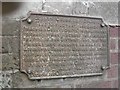
Old Bridge Marker by the B3078, Walford Bridge, Wimborne Minster Parish
Bridge Weight Plate by the B3078, in parish of Wimborne Minster (East Dorset District), Walford Bridge, South West corner of bridge parapet.
'Lost'
Inscription reads:-
COUNTY COUNCIL OF DORSET.
TAKE NOTICE THAT THIS BRIDGE
(WHICH IS A COUNTY BRIDGE) IS INSUFFICIENT
TO CARRY WEIGHTS BEYOND THE ORDINARY
TRAFFIC OF THE DISTRICT; AND THAT THE
OWNERS AND PERSONS IN CHARGE OF
LOCOMOTIVE TRACTION ENGINES AND OTHER
PONDEROUS CARRIAGES ARE WARNED AGAINST
USING THE BRIDGE FOR THE PASSAGE OF
ANY SUCH ENGINE OR CARRIAGE.
E. ARCHDALL FFOOKS
CLERK OF THE COUNTY COUNCIL OF DORSET
Walford Bridge is Grade II* Listed.
List Entry Number: 1119538 https://historicengland.org.uk/listing/the-list/list-entry/1119538
Surveyed
Milestone Society National ID: DO_WEIWIWbbr
Image: © M Faherty
Taken: 11 Apr 2007
0.04 miles
8
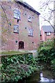
Walford Mill Wimborne
Now a craft centre, the mill once had two waterwheels of the undershot type about 2.4 metres in diameter. Little remains to show this except the wheel housings. At about 1900 these wheels were replaced by "British Empire Turbines" made by the Armfield Engineering Company of Fordingbridge. The mill building was extended and a furnace/boiler room was added on the ground floor. This was an alternative source of power for the mill when water was scarce.
Image: © Nigel Mykura
Taken: 26 Nov 2008
0.05 miles
9
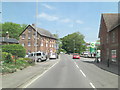
B3078 approaches Walford Bridge
There's an industrial building adjoining Walford Mill House which is Grade II listed. It's on the left of the picture and originated in the 19th C. It has English Heritage Building ID: 107102.
Image: © Stuart Logan
Taken: 4 Jun 2013
0.06 miles
10

Spillway, Walford Mill, Wimborne
This spillway was original in place to allow water from the millpond to overflow and bypass the mill and its waterwheels. the spillway is now permanently dry as the sluice gates have been removed emptying the millpond and only a small amount of water goes through the mill.
Image: © Nigel Mykura
Taken: 26 Nov 2008
0.06 miles