Old Bridge Marker by the B3078, Walford Bridge, Wimborne Minster
Introduction
The photograph on this page of Old Bridge Marker by the B3078, Walford Bridge, Wimborne Minster by M Faherty as part of the Geograph project.
The Geograph project started in 2005 with the aim of publishing, organising and preserving representative images for every square kilometre of Great Britain, Ireland and the Isle of Man.

There are currently over 7.5m images from over 14,400 individuals and you can help contribute to the project by visiting https://www.geograph.org.uk
Old Bridge Marker by the B3078, Walford Bridge, Wimborne Minster
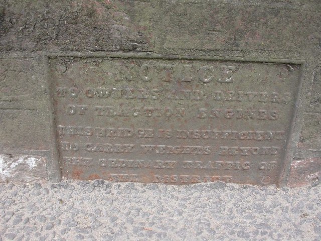
Image: © M Faherty Taken: 11 Apr 2007
Bridge Weight Plate by the B3078, in parish of Wimborne Minster (East Dorset District), Walford Bridge, on East parapet, mid bridge, visible from road or by leaning over parapet from footpath. Partly buried in tarmac. Inscription reads:- NOTICE TO OWNERS AND DRIVERS OF TRACTION ENGINES THIS BRIDGE IS INSUFFICIENT TO CARRY WEIGHTS BEYOND THE ORDINARY TRAFFIC OF THE DISTRICT Walford Bridge is Grade II* listed. List Entry Number: 1119538 https://historicengland.org.uk/listing/the-list/list-entry/1119538 Surveyed Milestone Society National ID: DO_WEIWIWabr
Images are licensed for reuse under creativecommons.org/licenses/by-sa/2.0
Image Location
Latitude
50.805297
Longitude
-1.987956