IMAGES TAKEN NEAR TO
Redcotts Lane, WIMBORNE, BH21 1JY
Introduction
This page details the photographs taken nearby to Redcotts Lane, BH21 1JY by members of the Geograph project.
The Geograph project started in 2005 with the aim of publishing, organising and preserving representative images for every square kilometre of Great Britain, Ireland and the Isle of Man.

There are currently over 7.5m images from over14,400 individuals and you can help contribute to the project by visiting https://www.geograph.org.uk
Image Map
Images are licensed for reuse under creativecommons.org/licenses/by-sa/2.0
Notes
- Clicking on the map will re-center to the selected point.
- The higher the marker number, the further away the image location is from the centre of the postcode.
Image Listing (479 Images Found)
Images are licensed for reuse under creativecommons.org/licenses/by-sa/2.0
Image
Details
Distance
1

No. 9 (of 12) the Green Plaques of Wimborne - Tivoli Theatre
Location: west side of West Borough (near junction with Priors Walk).
Image
Image: © Mike Searle
Taken: 22 Mar 2015
0.06 miles
2
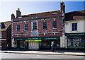
Wimborne - Tivoli Theatre
The former Tivoli Cinema with its Art Deco facade and interior was converted into a cinema from an C18 building known as Borough House. It continued successfully until it closed in 1980, only to be rescued after standing disused for ten years by a group of local enthusiasts. The venue is now a multi-purpose entertainment centre. Grade II listed.
http://www.imagesofengland.org.uk/Details/Default.aspx?id=107166&mode=adv
Image
Image: © Mike Searle
Taken: 22 Mar 2015
0.06 miles
3
Wimborne, Taphouse
The latest addition to Wimborne's pub scene, opened in 2013 on West Borough. Straight bar to right, drinking front, left and back; simple decor with bare brick and wooden panelling, background music. Cask ales on offer at my visit: six, served on gravity, including two from the local Six Arch Brewery. http://whatpub.com/pubs/SED/72/taphouse-wimborne
Image: © Mike Faherty
Taken: 9 Dec 2015
0.06 miles
4
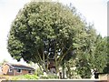
Tree House in Wimborne
Located on the edge of Westfield Close car park, the tree has grown round the house so solidly it couldn't fall out if it wanted to. It looks as though the tree was heavily pollarded 50 years ago, allowed to grow then the owner of the big house behind had a bright idea.....
Image: © John Palmer
Taken: 21 Apr 2009
0.06 miles
6
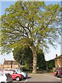
Ancient oak in car park
This fine tree is in Westfield Close car park, Wimborne, and is completely surrounded by tarmac. Its girth is 450 cms, indicating it was an acorn in the reign of Elizabeth I. Under good conditions, it would have another 450 years to live. But the tarmac prevents rain and nutrients getting to the roots, and will slowly choke the big tree. Just so people don't have far to walk to the shops.
Image: © John Palmer
Taken: 21 Apr 2009
0.07 miles
7
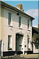
Former drill hall - West Borough
Apparently the two storey building with hall to rear was in use pre-WW1.
Image: © John M
Taken: 18 Sep 2014
0.07 miles
8
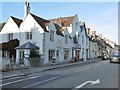
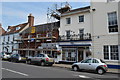
Wimborne, The Man in the Wall
Recently opened Wetherspoon's pub in West Borough, formerly the Conservative Club, and before that local government offices. Internally, imposing hall, eating and drinking areas left and right, with left back bar; old mosaic flooring, exposed brickwork, bookcases, games machines, beer garden. Ten cask ales were on offer at my visit, including six locals. The pub's name comes, according to a plaque, from a certain Anthony Ettrick, who decided he was going to die in 1693, had a coffin made with this date, and put in the Minster; he lasted until 1703, so the date had to be changed. The building is listed by English Heritage: http://www.imagesofengland.org.uk/Details/Default.aspx?id=107144&mode=adv http://www.jdwetherspoon.co.uk/home/pubs/the-man-in-the-wall
Image: © Mike Faherty
Taken: 1 May 2012
0.07 miles
9
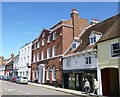
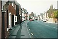
Wimborne, Dorset
View south along West Borough just beyond the junction with Priorswalk. The Minster can be seen in the distance.
Image: © Nigel Mykura
Taken: 12 Aug 2009
0.07 miles
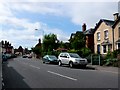
10
West Borough, Wimborne Minster in 1988
Taken from almost opposite the junction of School Road, which can be seen on the right; part of The Minster can be seen in the distance.
Image: © John Baker
Taken: 23 Apr 1988
0.07 miles