IMAGES TAKEN NEAR TO
Lower Woodbury, WAREHAM, BH20 7NN
Introduction
This page details the photographs taken nearby to BH20 7NN by members of the Geograph project.
The Geograph project started in 2005 with the aim of publishing, organising and preserving representative images for every square kilometre of Great Britain, Ireland and the Isle of Man.

There are currently over 7.5m images from over14,400 individuals and you can help contribute to the project by visiting https://www.geograph.org.uk
Image Map (Loading...)


Getting Data...Please wait
Leaflet Map data © OpenStreetMap
Images are licensed for reuse under creativecommons.org/licenses/by-sa/2.0
Notes
- Clicking on the map will re-center to the selected point.
- The higher the marker number, the further away the image location is from the centre of the postcode.
Image Listing (6 Images Found)
Images are licensed for reuse under creativecommons.org/licenses/by-sa/2.0
Image
Details
Distance
1
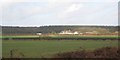
Bere Regis - Lane End
Lorry on Bere Road just approaching Lower Woodbury Cross, Lane End on its left. Lower Woodbury Farm to the right.
Image: © Peter Elsdon
Taken: 20 Nov 2009
0.03 miles
2
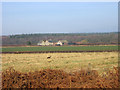
Lower Woodbury Farm near Bloxworth
The photo is taken from the zigzag path at the northern edge of Bere Heath. Note the Sika deer running through open fields. This Japanese species thrives in the Purbeck area and was first introduced into Dorset in the late 19th century
http://www.deer-uk.com/sika.htm
Image: © John Lamper
Taken: 5 Feb 2006
0.03 miles
3
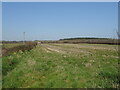
Field and hedgerow near Lower Woodbury Farm
Image: © JThomas
Taken: 23 Mar 2022
0.15 miles
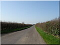
5
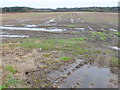
Fields at Lower Woodbury
View south east across waterlogged fields towards the northern edge of Wareham Forest.
Image: © Nigel Mykura
Taken: 1 Feb 2013
0.16 miles
6
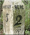
Old Milestone south east of Bere Regis
Carved stone post by the UC road, in parish of BERE REGIS (PURBECK District), 300m South South East of Lower Woodbury Farm, on edge of road in small trees and scrub, on North side of road. Dorset 3 (limestone), erected by the Wareham (North, South & West Branches) turnpike trust in the 19th century.
Inscription reads:-
: WAREHAM / 5 : : BERE / 2 :
Carved benchmark on bottom of right face.
Milestone Society National ID: DO_WABE05.
Image: © J Tybjerg
Taken: 27 Sep 2002
0.23 miles