IMAGES TAKEN NEAR TO
Cow Drove, WAREHAM, BH20 7JZ
Introduction
This page details the photographs taken nearby to Cow Drove, BH20 7JZ by members of the Geograph project.
The Geograph project started in 2005 with the aim of publishing, organising and preserving representative images for every square kilometre of Great Britain, Ireland and the Isle of Man.

There are currently over 7.5m images from over14,400 individuals and you can help contribute to the project by visiting https://www.geograph.org.uk
Image Map
Images are licensed for reuse under creativecommons.org/licenses/by-sa/2.0
Notes
- Clicking on the map will re-center to the selected point.
- The higher the marker number, the further away the image location is from the centre of the postcode.
Image Listing (22 Images Found)
Images are licensed for reuse under creativecommons.org/licenses/by-sa/2.0
Image
Details
Distance
1

The remains of a road junction, Bere Regis
This junction has been closed and the space beside the former road given to commercial use. It is part of the rearrangement of roads (A35 and A31) to avoid the centre of Bere Regis
Image: © David Smith
Taken: 6 Jul 2015
0.01 miles
2
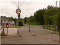
Bere Regis: postbox № BH20 195, North Street
North Street has been closed off at this point for many years – 20 or more – to prevent it from being used as a rat-run when the by-pass is busy. The small postbox has advertised last collection times of 5:30pm on weekdays and at 8am on Saturdays.
The circular roadsign, indicating that motor vehicles are prohibited, has been given a 90° turn at some point.
Image: © Chris Downer
Taken: 7 Jun 2009
0.04 miles
3
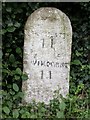
Old Milestone by the UC road, North Street, Bere Regis
Stone post (plate lost) by the UC road, in parish of BERE REGIS (PURBECK District), North Street, Bere Regis, by entrance to Bere Regis sports club, on East side of road, opposite Snow Hill Lane. Dorset 2 (limestone), erected by the Puddletown & Wimborne turnpike trust in the 19th century.
Inscription reads:-
DORCHESTER
11
WIMBORNE
11
Milestone Society National ID: DO_DOWB11.
Image: © John Long
Taken: 14 May 2002
0.04 miles
4
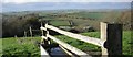
Bere Regis - Woodbury Hill
Looking west from the water trough towards the white building of the Bere Regis sports Club. Townsend Business park is to the right. The cutting running from the trees to the right, towards the centre of the picture guides the A35 to Dorchester and beyond.
Image: © Peter Elsdon
Taken: 25 Nov 2009
0.06 miles
6
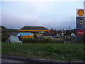
Bere Regis
'Keep going well' Service Station at the junction of the A31 going right towards Ringwood and the A35 to the front of Townsend Business Park then left towards Dorchester. Maddox Burrow Farm is on the hill.
Image: © Peter Elsdon
Taken: 25 Nov 2009
0.08 miles
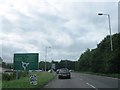
7
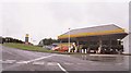
Bere Regis: garage at the end of the A31
The A31, which starts at Guildford, ends its journey at Bere Regis where it meets the A35 from Poole towards Exeter. At the junction (the roundabout signage visible left of picture) is this petrol station.
Image: © Chris Downer
Taken: 24 Jun 2007
0.08 miles
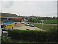
8

Filling station at Bere Regis
At the roundabout junction of the A31 and A35 north-east of Bere Regis
Image: © David Smith
Taken: 6 Jul 2015
0.09 miles