IMAGES TAKEN NEAR TO
Blandford Road, WAREHAM, BH20 7JQ
Introduction
This page details the photographs taken nearby to Blandford Road, BH20 7JQ by members of the Geograph project.
The Geograph project started in 2005 with the aim of publishing, organising and preserving representative images for every square kilometre of Great Britain, Ireland and the Isle of Man.

There are currently over 7.5m images from over14,400 individuals and you can help contribute to the project by visiting https://www.geograph.org.uk
Image Map (Loading...)


Getting Data...Please wait
Leaflet Map data © OpenStreetMap
Images are licensed for reuse under creativecommons.org/licenses/by-sa/2.0
Notes
- Clicking on the map will re-center to the selected point.
- The higher the marker number, the further away the image location is from the centre of the postcode.
Image Listing (3 Images Found)
Images are licensed for reuse under creativecommons.org/licenses/by-sa/2.0
Image
Details
Distance
1
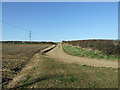
Jubilee Trail, with track leading to Muddox Barrow Farm
Image: © Lorraine and Keith Bowdler
Taken: 10 Mar 2012
0.17 miles
2
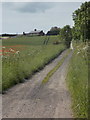
Bere Regis: track to Muddox Barrow Farm
The track leads from the A31, just behind us, to the farmhouse which is visible on the top of the hill.
Image: © Chris Downer
Taken: 8 Jun 2014
0.23 miles
3
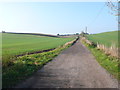
Track to Muddox Barrow Farm
The track to the farm which leads off the A31 just north of Bere Regis is bordered with arable fields of wheat on both sides. The farm which is locatred exactly on the grid line between SY 8495 and SY 8496 can be seen in the distance on top of the hill.
Image: © Nigel Mykura
Taken: 15 Nov 2011
0.23 miles