IMAGES TAKEN NEAR TO
West Street, WAREHAM, BH20 7HP
Introduction
This page details the photographs taken nearby to West Street, BH20 7HP by members of the Geograph project.
The Geograph project started in 2005 with the aim of publishing, organising and preserving representative images for every square kilometre of Great Britain, Ireland and the Isle of Man.

There are currently over 7.5m images from over14,400 individuals and you can help contribute to the project by visiting https://www.geograph.org.uk
Image Map
Images are licensed for reuse under creativecommons.org/licenses/by-sa/2.0
Notes
- Clicking on the map will re-center to the selected point.
- The higher the marker number, the further away the image location is from the centre of the postcode.
Image Listing (123 Images Found)
Images are licensed for reuse under creativecommons.org/licenses/by-sa/2.0
Image
Details
Distance
1
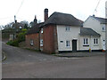
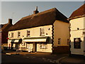
Toll Gate Cottage, Bere Regis
A former Toll House at 72 West Street, on the corner of Butt Lane. Used by the Wimborne and Piddletown Turnpike Trust, up to the mid 19ᵗʰ C.
Milestone Society National ID: DO.BER
Image: © Colin Payne
Taken: 17 Mar 2023
0.02 miles
2
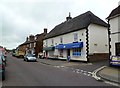
Bere Regis, post office & stores
On West Street.
Image: © Mike Faherty
Taken: 8 Sep 2011
0.10 miles
3
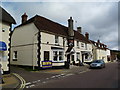
Bere Regis, Drax Arms
Hall & Woodhouse village pub on West Street, named after a local land-owner. Internally, two rooms appear to have been knocked through, each with a (potentially) wood-burning fire place; darts, games machine. Cask ales on offer at my visit: Badger, Fursty Ferret. For some customer comments, see http://www.beerintheevening.com/pubs/s/24/24138/Drax_Arms/Bere_Regis
Image: © Mike Faherty
Taken: 8 Sep 2011
0.11 miles
4
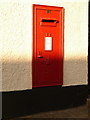
Bere Regis: postbox № BH20 194, West Street
This Elizabeth II-reigb postbox is set into the wall of the post office (see Image) and is emptied finally at 4:45pm on weekdays and at 10:15am on Saturdays.
Image: © Chris Downer
Taken: 12 Sep 2009
0.12 miles
5
Bere Regis: village stores and post office
These two outlets are separate premises, rather than the common setup of having the post office in the back of the village shop.
Image: © Chris Downer
Taken: 12 Sep 2009
0.13 miles
6
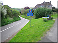
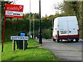
Shitterton
The lower road leads to the delightful village of Sitterton. The name was changed in deference to Queen Victoria when she came to Dorset, but the original name is still used locally. The road on the right goes on to meet the A35 westbound to Dorchester.
Image: © John Lamper
Taken: 1 May 2006
0.13 miles
7
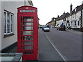
Bere Regis: red phone box in the High Street
One of two traditional K6 phone boxes in Bere Regis - the other is Image
Image: © Chris Downer
Taken: 25 May 2013
0.13 miles
8
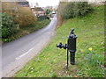
Shitterton, village pump
At the top of the lane leading to the settlement. The pump has been well preserved, though the handle seems fixed. A trademark shows that it was made by Lee, Howl & Co of Tipton: http://www.villagepumps.org.uk/manufs.htm
Image: © Mike Faherty
Taken: 9 Mar 2013
0.14 miles
9
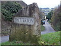
Shitterton: a robust village sign
The standard nameplate on two posts was frequently stolen from this amusingly named hamlet, and this problem was solved by the introduction of this large stone with SHITTERTON inscribed on both sides - this one will surely take some shifting!
See Image for one of the previous signs, and within it a link to another picture.
Image: © Chris Downer
Taken: 28 Nov 2013
0.14 miles
10
Shitterton, Bere Regis, Dorset
What prompted me to obtain this image was the interesting mix of vertical and skewed horizontal lines in this view.
Image: © Brian Robert Marshall
Taken: 18 Oct 2007
0.15 miles