IMAGES TAKEN NEAR TO
West Morden, WAREHAM, BH20 7DU
Introduction
This page details the photographs taken nearby to BH20 7DU by members of the Geograph project.
The Geograph project started in 2005 with the aim of publishing, organising and preserving representative images for every square kilometre of Great Britain, Ireland and the Isle of Man.

There are currently over 7.5m images from over14,400 individuals and you can help contribute to the project by visiting https://www.geograph.org.uk
Image Map
Images are licensed for reuse under creativecommons.org/licenses/by-sa/2.0
Notes
- Clicking on the map will re-center to the selected point.
- The higher the marker number, the further away the image location is from the centre of the postcode.
Image Listing (5 Images Found)
Images are licensed for reuse under creativecommons.org/licenses/by-sa/2.0
Image
Details
Distance
1
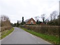
Whitefield, Chapel Cottage
Bearing a plaque above the porch "Wesleyan Chapel 1873"; now residential.
Image: © Mike Faherty
Taken: 2 Mar 2013
0.01 miles
2
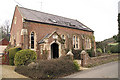
Former Wesleyan Chapel, Whitefield
The building dates from 1873
Image: © John Lamper
Taken: 13 Jan 2006
0.04 miles
3
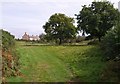
Cottages at Whitefield
A group of 4 cottages betgween Whitefield and West Morden, seen from the apex of a triangle of lanes.
Image: © Derek Harper
Taken: 28 Sep 2007
0.11 miles
4
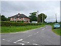
Cottages at Whitefield
This house is at a minor cross roads just south of West Morden in Dorset.
Image: © Nigel Mykura
Taken: 12 Aug 2009
0.17 miles
5
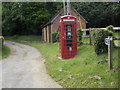
Morden: telephone box at Whitefield
This red phone box stands at the start of a track, which is also a public footpath, in the tiny straggling hamlet of Whitefield, to the west of the parish.
Image: © Chris Downer
Taken: 16 Jun 2013
0.17 miles