IMAGES TAKEN NEAR TO
Sandford Drive, WAREHAM, BH20 7DG
Introduction
This page details the photographs taken nearby to Sandford Drive, BH20 7DG by members of the Geograph project.
The Geograph project started in 2005 with the aim of publishing, organising and preserving representative images for every square kilometre of Great Britain, Ireland and the Isle of Man.

There are currently over 7.5m images from over14,400 individuals and you can help contribute to the project by visiting https://www.geograph.org.uk
Image Map (Loading...)


Getting Data...Please wait
Leaflet Map data © OpenStreetMap
Images are licensed for reuse under creativecommons.org/licenses/by-sa/2.0
Notes
- Clicking on the map will re-center to the selected point.
- The higher the marker number, the further away the image location is from the centre of the postcode.
Image Listing (14 Images Found)
Images are licensed for reuse under creativecommons.org/licenses/by-sa/2.0
Image
Details
Distance
1
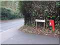
Sandford: postbox № BH20 223, Sandford Drive
A small postbox, rather resplendent for those travelling southbound on the A351 but entirely unseen to those going north. It is emptied finally at 5:15pm on weekdays and at 8am on Saturdays.
Image: © Chris Downer
Taken: 17 Jan 2009
0.12 miles
2
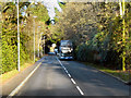
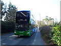
A351 Sandford Road
HF59DMO, a Wilts & Dorset Scania bus operating the "Purbeck Breezer" service on Sandford Road (A351)
Image: © David Dixon
Taken: 18 Dec 2012
0.13 miles
3
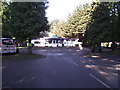
Sandford Park, Campsite reception
This is large site consisting of both static vans and over 200 pitches.
An inexpensive family holiday.
Image: © Anthony Vosper
Taken: 24 Aug 2011
0.13 miles
4
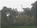
Sandford near Wareham
Phone mast and WWII anti-aircraft gun tower, Sandford area.
Image: © Peter Elsdon
Taken: 27 Oct 2009
0.18 miles
6

Sandford near Wareham
Is this another water tower in the Sandford area? Looking from the east side of Gore Hill.
Image: © Peter Elsdon
Taken: 27 Oct 2009
0.19 miles
9

Defending Dorset: Holton Heath: Light Anti-Aircraft Battery - Bofors gun tower no. 2 (21)
-
LAA Battery: DoB ID: e27075
This is the second of two surviving Holton Heath Bofors 40 mm LAA gun towers; this one is on a bluff on farm land to the west of Sandford House, and about 650 metres north west of its companion further east. Both sites provided light anti-aircraft defence during WW2 for the RNCF of Holton Heath. The condition of both towers here is not good, one in particular looks close to collapse, and so boundary fencing has been erected around the likely danger area. The towers now share the site with a mobile phone company's telecommunications mast.
Image
Image: © Mike Searle
Taken: 27 Feb 2017
0.21 miles
10

Defending Dorset: Holton Heath: Light Anti-Aircraft Battery - Bofors gun tower no. 2 (22)
-
LAA Battery: DoB ID: e27075
Unlike its identical companion further east, subsidence has particularly affected the structure, such that it is far more obvious here that there are two distinctly separate towers. The narrow gap that originally separated them has widened considerably due to the undermined tower nearest the camera having lurched sideways from the vertical.
Image
Image: © Mike Searle
Taken: 27 Feb 2017
0.21 miles