IMAGES TAKEN NEAR TO
Higher Wood, WAREHAM, BH20 6NG
Introduction
This page details the photographs taken nearby to Higher Wood, BH20 6NG by members of the Geograph project.
The Geograph project started in 2005 with the aim of publishing, organising and preserving representative images for every square kilometre of Great Britain, Ireland and the Isle of Man.

There are currently over 7.5m images from over14,400 individuals and you can help contribute to the project by visiting https://www.geograph.org.uk
Image Map (Loading...)


Getting Data...Please wait
Leaflet Map data © OpenStreetMap
Images are licensed for reuse under creativecommons.org/licenses/by-sa/2.0
Notes
- Clicking on the map will re-center to the selected point.
- The higher the marker number, the further away the image location is from the centre of the postcode.
Image Listing (14 Images Found)
Images are licensed for reuse under creativecommons.org/licenses/by-sa/2.0
Image
Details
Distance
1
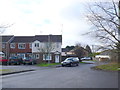
Residential Accommodation Bovington Camp
These houses are just to the east of Kin George V Rd, the main north south road through the camp, near the centre of the camp
Image: © Nigel Mykura
Taken: 1 Feb 2013
0.13 miles
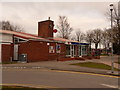
2
Bovington Camp, HIVE
Bovington Community Office, a Services information centre, opposite Allenby Barracks. http://www.mod.uk/DefenceInternet/DefenceFor/ServiceCommunity/Hive/AboutTheArmyHiveInformationService.htm
Image: © Mike Faherty
Taken: 25 Feb 2012
0.16 miles
3
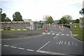
Entrance to Armoury Centre, Allenby Barracks
This is the junction of Amiens Rd with King George V Rd in the centre of Bovington Camp.
Image: © Nigel Mykura
Taken: 7 Jun 2015
0.17 miles
4
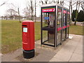
Bovington: postbox № BH20 287 and phones, Gaza Road
This modern postbox faces Image, in the centre of the 'village'.
Image: © Chris Downer
Taken: 13 Feb 2010
0.17 miles
5
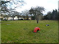
Bovington Camp, open space
A novel way of recycling old tyres.
Image: © Mike Faherty
Taken: 25 Feb 2012
0.18 miles
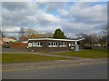
6
Bovington: the post office
A convenience store and post office, in the part of the army camp which has all the amenity type buildings such as sports centre, fish & chip shop, hairdressers', etc.
Image: © Chris Downer
Taken: 13 Feb 2010
0.18 miles
7
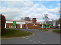
Bovington Camp, post office & stores
Operated by Londis.
Image: © Mike Faherty
Taken: 25 Feb 2012
0.19 miles
9
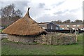
Ancient and modern houses, Bovington, Dorset
A small reconstruction of an Iron age roundhouse in the grounds of Bovington First School. Constructed by the outreach team from the Ancient Technology Centre, Cranborne, Dorset. Children from the school helped in the construction, weaving and daubing the wall, and making the enclosure fence. This little building is an extra fun classroom.
Image: © Clive Perrin
Taken: 4 Mar 2009
0.22 miles
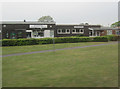
10
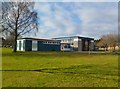
Bovington Camp, RAC Memorial Hall
Offering community activities, and available for hire.
Image: © Mike Faherty
Taken: 25 Feb 2012
0.22 miles