IMAGES TAKEN NEAR TO
Robertson Road, WAREHAM, BH20 6JT
Introduction
This page details the photographs taken nearby to Robertson Road, BH20 6JT by members of the Geograph project.
The Geograph project started in 2005 with the aim of publishing, organising and preserving representative images for every square kilometre of Great Britain, Ireland and the Isle of Man.

There are currently over 7.5m images from over14,400 individuals and you can help contribute to the project by visiting https://www.geograph.org.uk
Image Map (Loading...)


Getting Data...Please wait
Leaflet Map data © OpenStreetMap
Images are licensed for reuse under creativecommons.org/licenses/by-sa/2.0
Notes
- Clicking on the map will re-center to the selected point.
- The higher the marker number, the further away the image location is from the centre of the postcode.
Image Listing (5 Images Found)
Images are licensed for reuse under creativecommons.org/licenses/by-sa/2.0
Image
Details
Distance
1
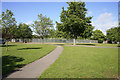
Tennis and Basketball courts
The dashed area marked on the 1:50000 is playing courts.
Image: © Stuart Cankett
Taken: 19 May 2007
0.04 miles
2
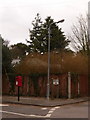
Bovington: postbox № BH20 178, Swinton Avenue
A small postbox serving some of the residential quarters of the Bovington army camp, situated on the corner of Swinton Avenue and Churchill Road and emptied finally at 4:45pm on weekdays and at 8:30am on Saturdays.
Image: © Chris Downer
Taken: 13 Feb 2010
0.07 miles
3
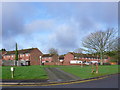
Residential Accommodation Bovington Camp
This is a very large camp with considerable number of houses on site for the soldiers. These houses are close to the centre of the camp.
Image: © Nigel Mykura
Taken: 1 Feb 2013
0.23 miles
4
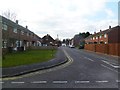
Bovington Camp, New Road
Married quarters.
Image: © Mike Faherty
Taken: 25 Feb 2012
0.24 miles
5
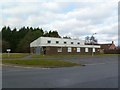
Bovington Camp, ASU
Accommodation Services Unit, providing furniture, household equipment and storage for families arriving or moving. http://bovingtonhive.blogspot.com/2012/02/asu-accommodation-services-unit.html
Image: © Mike Faherty
Taken: 25 Feb 2012
0.25 miles