IMAGES TAKEN NEAR TO
Bovington, WAREHAM, BH20 6JA
Introduction
This page details the photographs taken nearby to BH20 6JA by members of the Geograph project.
The Geograph project started in 2005 with the aim of publishing, organising and preserving representative images for every square kilometre of Great Britain, Ireland and the Isle of Man.

There are currently over 7.5m images from over14,400 individuals and you can help contribute to the project by visiting https://www.geograph.org.uk
Image Map (Loading...)


Getting Data...Please wait
Leaflet Map data © OpenStreetMap
Images are licensed for reuse under creativecommons.org/licenses/by-sa/2.0
Notes
- Clicking on the map will re-center to the selected point.
- The higher the marker number, the further away the image location is from the centre of the postcode.
Image Listing (2 Images Found)
Images are licensed for reuse under creativecommons.org/licenses/by-sa/2.0
Image
Details
Distance
1
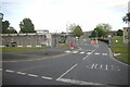
Entrance to Armoury Centre, Allenby Barracks
This is the junction of Amiens Rd with King George V Rd in the centre of Bovington Camp.
Image: © Nigel Mykura
Taken: 7 Jun 2015
0.23 miles
2
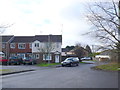
Residential Accommodation Bovington Camp
These houses are just to the east of Kin George V Rd, the main north south road through the camp, near the centre of the camp
Image: © Nigel Mykura
Taken: 1 Feb 2013
0.24 miles