IMAGES TAKEN NEAR TO
East Burton Road, WAREHAM, BH20 6HE
Introduction
This page details the photographs taken nearby to East Burton Road, BH20 6HE by members of the Geograph project.
The Geograph project started in 2005 with the aim of publishing, organising and preserving representative images for every square kilometre of Great Britain, Ireland and the Isle of Man.

There are currently over 7.5m images from over14,400 individuals and you can help contribute to the project by visiting https://www.geograph.org.uk
Image Map (Loading...)


Getting Data...Please wait
Leaflet Map data © OpenStreetMap
Images are licensed for reuse under creativecommons.org/licenses/by-sa/2.0
Notes
- Clicking on the map will re-center to the selected point.
- The higher the marker number, the further away the image location is from the centre of the postcode.
Image Listing (15 Images Found)
Images are licensed for reuse under creativecommons.org/licenses/by-sa/2.0
Image
Details
Distance
1
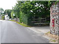
East Burton: postbox № BH20 90
An Elizabeth II-reign postbox set into a wall at the north of the village. It is emptied finally at 4pm on weekdays and at 9:15am on Saturdays.
Image: © Chris Downer
Taken: 20 Jun 2009
0.01 miles
2
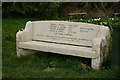
Bench at East Burton, Dorset
An interesting, and useful, family memorial.
Image: © Peter Trimming
Taken: 30 Mar 2013
0.03 miles
3
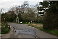
East Burton, Dorset
According to the map, there should be a telephone box on this corner; it looks to be long gone. A footpath bears off to the right.
Image: © Peter Trimming
Taken: 30 Mar 2013
0.04 miles
4
Fromedale B & B, East Burton, Wool
Image: © Becky Williamson
Taken: 27 Aug 2018
0.05 miles
5
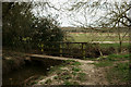
Bridge Across the Steam
Located on the northern edge of East Burton.
Image: © Peter Trimming
Taken: 30 Mar 2013
0.07 miles
6
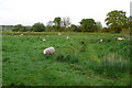
Sheep on the Moors East Burton
The Moors is a flat area of water meadow, north east of the village alongside the River Frome
Image: © Nigel Mykura
Taken: 10 May 2008
0.08 miles
7
Buildings at Talbot Farm
Most of this square is low lying land on the flood plain of the river Frome. This small road is on the south side of the flood plain next to Wool village. It is classed as an Other Route with Public Access. ORPA.
Image: © Nigel Mykura
Taken: 2 Feb 2013
0.08 miles
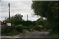
8
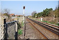
Railway line
The main Dorchester to London line.
Image: © N Chadwick
Taken: 9 Apr 2008
0.12 miles
9

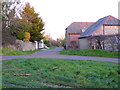
Water Meadow Lane, East Burton
Water Meadow Lane lies between East Burton Road and the River Frome
Image: © Mike Farley
Taken: 21 Apr 2006
0.12 miles
10
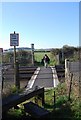
Footpath Crossing railway, East Burton
Crossing the main Weymouth to London trainline
Image: © N Chadwick
Taken: 9 Apr 2008
0.13 miles