IMAGES TAKEN NEAR TO
Breach Field, WAREHAM, BH20 6DQ
Introduction
This page details the photographs taken nearby to Breach Field, BH20 6DQ by members of the Geograph project.
The Geograph project started in 2005 with the aim of publishing, organising and preserving representative images for every square kilometre of Great Britain, Ireland and the Isle of Man.

There are currently over 7.5m images from over14,400 individuals and you can help contribute to the project by visiting https://www.geograph.org.uk
Image Map (Loading...)


Getting Data...Please wait
Leaflet Map data © OpenStreetMap
Images are licensed for reuse under creativecommons.org/licenses/by-sa/2.0
Notes
- Clicking on the map will re-center to the selected point.
- The higher the marker number, the further away the image location is from the centre of the postcode.
Image Listing (190 Images Found)
Images are licensed for reuse under creativecommons.org/licenses/by-sa/2.0
Image
Details
Distance
1

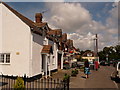
Wool Royal British Legion
On Colliers Lane.
Image: © Mike Faherty
Taken: 28 Mar 2013
0.08 miles
2
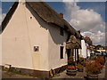
![Wool houses [1]](https://s3.geograph.org.uk/geophotos/07/25/80/7258067_4a8180ea_120x120.jpg)
Wool houses [1]
Cowslip Cottage, Station Road, was probably built in the 18th century. Constructed of stuccoed rubble stone under a thatch roof. There is a later rear extension. At one time the cottage and the adjoining weatherboarded building operated as tearooms and later as a restaurant. Listed, grade II, with details at: https://historicengland.org.uk/listing/the-list/list-entry/1120336
Wool is a large village in Dorset, midway between Dorchester and Poole, both about 10 miles distant. Set on the south bank of the River Frome, the village includes Bovington Camp army base to the north. The place-name 'Wool' is first recorded in Anglo-Saxon Writs in the first years of the 11th century. The ruins of Bindon Abbey are nearby, demolished in 1539, the stone was used to build castles in Portland, Lulworth and Sandsfoot.
Image: © Michael Dibb
Taken: 31 May 2022
0.11 miles
3
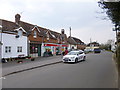
Wool: the post office and neighbours
One of Wool's convenience stores houses the village post office, among attractive frontages on the High Street.
Wool's post office was established on 4 October 1843, becoming a money order & savings bank on 1 November 1884 and a telegraph office on 1 August 1888.
Image: © Chris Downer
Taken: 25 Jul 2009
0.11 miles
4
Wool: Jumpers Cottage
A picturesque thatched cottage on the High Street, with Image beyond.
Image: © Chris Downer
Taken: 25 Jul 2009
0.12 miles
5
Wool: Kingdom Hall of Jehovah?s Witnesses
This place of worship stands on the corner of High Street and High Street Close.
Image: © Chris Downer
Taken: 25 Jul 2009
0.12 miles
6
![Wool houses [4]](https://s1.geograph.org.uk/geophotos/07/25/80/7258073_04afad14_120x120.jpg)
Wool houses [4]
Jumpers Cottage, number 9 High Street, was formerly two cottages. Probably built in the 18th century. Constructed of plastered rubble stone under a thatch roof. The windows are all horizontally sliding sash windows. A former outbuilding at the rear is now incorporated into the cottage. Listed, grade II, with details at: https://historicengland.org.uk/listing/the-list/list-entry/1120371
Wool is a large village in Dorset, midway between Dorchester and Poole, both about 10 miles distant. Set on the south bank of the River Frome, the village includes Bovington Camp army base to the north. The place-name 'Wool' is first recorded in Anglo-Saxon Writs in the first years of the 11th century. The ruins of Bindon Abbey are nearby, demolished in 1539, the stone was used to build castles in Portland, Lulworth and Sandsfoot.
Image: © Michael Dibb
Taken: 31 May 2022
0.12 miles
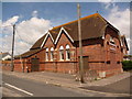
7
Wool: postbox № BH20 275 and library, Collier?s Lane
This postbox stands outside the library and community centre, and receives its final collection at 5pm on weekdays and 9:15am on Saturdays.
Image: © Chris Downer
Taken: 25 Jul 2009
0.12 miles
8
Wool Post Office
Post office and Spar store on High Street.
Image: © Mike Faherty
Taken: 28 Mar 2013
0.12 miles
10
![Wool houses [3]](https://s0.geograph.org.uk/geophotos/07/25/80/7258072_4e8c84e6_120x120.jpg)
Wool houses [3]
Tumbledown Cottage, number 8 High Street, was probably built in the 18th century. Constructed of plastered rubble stone under a thatch roof. There is a large outbuilding at the rear. Listed, grade II, with details at: https://historicengland.org.uk/listing/the-list/list-entry/1152923
Wool is a large village in Dorset, midway between Dorchester and Poole, both about 10 miles distant. Set on the south bank of the River Frome, the village includes Bovington Camp army base to the north. The place-name 'Wool' is first recorded in Anglo-Saxon Writs in the first years of the 11th century. The ruins of Bindon Abbey are nearby, demolished in 1539, the stone was used to build castles in Portland, Lulworth and Sandsfoot.
Image: © Michael Dibb
Taken: 31 May 2022
0.12 miles