IMAGES TAKEN NEAR TO
Locks Piece, WAREHAM, BH20 6DP
Introduction
This page details the photographs taken nearby to Locks Piece, BH20 6DP by members of the Geograph project.
The Geograph project started in 2005 with the aim of publishing, organising and preserving representative images for every square kilometre of Great Britain, Ireland and the Isle of Man.

There are currently over 7.5m images from over14,400 individuals and you can help contribute to the project by visiting https://www.geograph.org.uk
Image Map
Images are licensed for reuse under creativecommons.org/licenses/by-sa/2.0
Notes
- Clicking on the map will re-center to the selected point.
- The higher the marker number, the further away the image location is from the centre of the postcode.
Image Listing (163 Images Found)
Images are licensed for reuse under creativecommons.org/licenses/by-sa/2.0
Image
Details
Distance
1
![Wool houses [1]](https://s3.geograph.org.uk/geophotos/07/25/80/7258067_4a8180ea_120x120.jpg)
Wool houses [1]
Cowslip Cottage, Station Road, was probably built in the 18th century. Constructed of stuccoed rubble stone under a thatch roof. There is a later rear extension. At one time the cottage and the adjoining weatherboarded building operated as tearooms and later as a restaurant. Listed, grade II, with details at: https://historicengland.org.uk/listing/the-list/list-entry/1120336
Wool is a large village in Dorset, midway between Dorchester and Poole, both about 10 miles distant. Set on the south bank of the River Frome, the village includes Bovington Camp army base to the north. The place-name 'Wool' is first recorded in Anglo-Saxon Writs in the first years of the 11th century. The ruins of Bindon Abbey are nearby, demolished in 1539, the stone was used to build castles in Portland, Lulworth and Sandsfoot.
Image: © Michael Dibb
Taken: 31 May 2022
0.03 miles
2
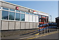
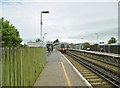
Wool railway station
On the mainline from London to Weymouth, the only stop between Wareham & Dorchester.
Image: © N Chadwick
Taken: 9 Apr 2008
0.04 miles
3
Exit from Wool station platform 2, Dorset
Between the two buildings for Station Road.
Image: © Jaggery
Taken: 21 Sep 2022
0.04 miles
4
Brick building on platform 2, Wool station, Dorset
The rear of a building facing Station Road.
Image: © Jaggery
Taken: 21 Sep 2022
0.04 miles
5
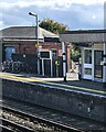
Wool Station looking towards Weymouth
Looking towards Weymouth the signal box controls the level crossing at the west end of the station
Image: © roger geach
Taken: 4 Jul 2010
0.05 miles
6
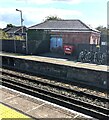
Wool Station
On the Waterloo to Weymouth line; a Class 444 EMU is leaving Platform 2, Weymouth-bound.
Image: © Mike Faherty
Taken: 12 Sep 2016
0.05 miles
8
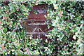
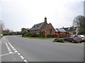
Benchmark on Wool Methodist Chapel, Station Road
Ordnance Survey cut mark benchmark described on the Bench Mark Database at http://www.bench-marks.org.uk/bm38555
Image: © Roger Templeman
Taken: 8 Jul 2011
0.05 miles
9
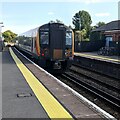
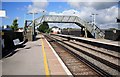
444008, Wool, Dorset
The South Western Railway Class 444 5-coach electric multiple unit from Weymouth to London Waterloo speeds eastwards through Wool station in September 2022.
Image: © Jaggery
Taken: 21 Sep 2022
0.05 miles
10
![Wool Buildings [2]](https://s0.geograph.org.uk/geophotos/07/25/80/7258068_4922fff6_120x120.jpg)
Wool Buildings [2]
Wool Methodist church, Station Road, was built in 1893. Constructed of red brick with ashlar dressings under a slate roof.
Wool is a large village in Dorset, midway between Dorchester and Poole, both about 10 miles distant. Set on the south bank of the River Frome, the village includes Bovington Camp army base to the north. The place-name 'Wool' is first recorded in Anglo-Saxon Writs in the first years of the 11th century. The ruins of Bindon Abbey are nearby, demolished in 1539, the stone was used to build castles in Portland, Lulworth and Sandsfoot.
Image: © Michael Dibb
Taken: 31 May 2022
0.05 miles