IMAGES TAKEN NEAR TO
Church Lane, WAREHAM, BH20 6AW
Introduction
This page details the photographs taken nearby to Church Lane, BH20 6AW by members of the Geograph project.
The Geograph project started in 2005 with the aim of publishing, organising and preserving representative images for every square kilometre of Great Britain, Ireland and the Isle of Man.

There are currently over 7.5m images from over14,400 individuals and you can help contribute to the project by visiting https://www.geograph.org.uk
Image Map (Loading...)


Getting Data...Please wait
Leaflet Map data © OpenStreetMap
Images are licensed for reuse under creativecommons.org/licenses/by-sa/2.0
Notes
- Clicking on the map will re-center to the selected point.
- The higher the marker number, the further away the image location is from the centre of the postcode.
Image Listing (13 Images Found)
Images are licensed for reuse under creativecommons.org/licenses/by-sa/2.0
Image
Details
Distance
1
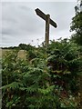
Signpost near East Stoke, Dorset
Gives information about the Purbeck Way and directions to local places including Wareham.
Image: © Tim Marshall
Taken: 8 Jul 2020
0.08 miles
2
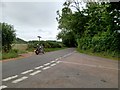
Road junction near East Stoke, Dorset
One of the many minor roads in Dorset, part of the Purbeck Way.
Image: © Tim Marshall
Taken: 8 Jul 2020
0.08 miles
3
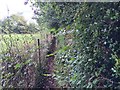
East Stoke, footpath
An overgrown diverted footpath to Church Lane.
Image: © Mike Faherty
Taken: 12 Sep 2016
0.09 miles
4
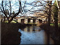
River Laboratory
This laboratory straddles the River Frome at East Stoke. A nearby sign indicates it as the Centre for Ecology and Hydrology, Institute for Freshwater Ecology.
Image: © David Squire
Taken: 1 Jan 2006
0.09 miles
5
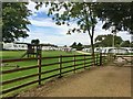
East Stoke, campsite
Manor Farm Camping Park, on Church Lane: http://www.ukcampsite.co.uk/sites/reviews.asp?revid=1246
Image: © Mike Faherty
Taken: 12 Sep 2016
0.10 miles
6
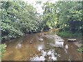
East Stoke, River Frome
Looking downstream from the bridge on Church Lane. This is the southern arm of the river.
Image: © Mike Faherty
Taken: 12 Sep 2016
0.13 miles
7
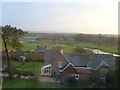
River Frome, East Stoke, Dorset
This part of the River Frome is a classic meandering river. Purbeck Hills in distance. Photo taken from tower of the former church of St Mary the Virgin, now three private residences. Former East Stoke school in foreground. Mainline railway to Weymouth runs through this photo (not clearly visible).
Image: © Alison Gathercole
Taken: 14 Feb 2004
0.15 miles
8
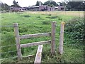
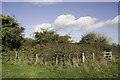
East Stoke, stile
Giving access to paddocks. The building in the distance is a research centre, supported by Bournemouth University, Queens College London, Freshwater Biological Association, and Game & Wildlife Conservation Trust.
Image: © Mike Faherty
Taken: 12 Sep 2016
0.16 miles
9
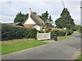
East Stoke, Holme Cottage
C18 thatched cottage on Church Lane; listed by Historic England (Grade II): http://www.imagesofengland.org.uk/Details/Default.aspx?id=108348&mode=adv
Image: © Mike Faherty
Taken: 12 Sep 2016
0.20 miles
10
Overgrown remains of St Mary's Church, East Stoke
This is the site of the 13th century church of St. Mary's, located in the flood meadows at East Stoke. There were apparently some concerns about flooding so, in 1828, a new church was built on higher ground at Stokeford, designed by Owen of Portsmouth. In 1988 the ecclesiastical parish of East Stoke was merged with that of Wool, and the church building was sold and converted into 3 private residences. Sadly the access to this historic site is now overgrown and it has become inaccessible. For photo of 1828 church, see Image
Image: © Becky Williamson
Taken: 8 Oct 2017
0.20 miles