IMAGES TAKEN NEAR TO
Holme Lane, WAREHAM, BH20 6AP
Introduction
This page details the photographs taken nearby to Holme Lane, BH20 6AP by members of the Geograph project.
The Geograph project started in 2005 with the aim of publishing, organising and preserving representative images for every square kilometre of Great Britain, Ireland and the Isle of Man.

There are currently over 7.5m images from over14,400 individuals and you can help contribute to the project by visiting https://www.geograph.org.uk
Image Map
Images are licensed for reuse under creativecommons.org/licenses/by-sa/2.0
Notes
- Clicking on the map will re-center to the selected point.
- The higher the marker number, the further away the image location is from the centre of the postcode.
Image Listing (10 Images Found)
Images are licensed for reuse under creativecommons.org/licenses/by-sa/2.0
Image
Details
Distance
1
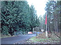
Grenade Range
Entrance to the MoD grenade range at Highwood Heath. Much of the area between here and the coast is military land comprising training areas and ranges.
Image: © David Squire
Taken: 1 Jan 2006
0.22 miles
2
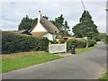
East Stoke, Holme Cottage
C18 thatched cottage on Church Lane; listed by Historic England (Grade II): http://www.imagesofengland.org.uk/Details/Default.aspx?id=108348&mode=adv
Image: © Mike Faherty
Taken: 12 Sep 2016
0.23 miles
4
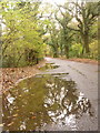
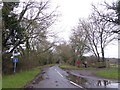
East Stoke: Holme Lane
A few puddles, after a couple of days of heavy rain, reflect the autumn colours that surround this leafy lane between Wool and East Holme.
Image: © Chris Downer
Taken: 22 Nov 2009
0.23 miles
5
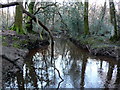
Luckford Lake
The scrub appears to have been cleared from this part of the heath where the small tributary on the right joins the larger stream known as Luckford Lake which is itself a tributary of the River Frome. The scrub clearance may have been done by the MOD who use large parts of this area as training grounds.
Image: © Nigel Mykura
Taken: 2 Feb 2013
0.24 miles
6
East Stoke, street furniture
Postbox (BH20 220), seat, notice board and litter bin at the crossroads.
Image: © Mike Faherty
Taken: 22 Sep 2016
0.24 miles
7
Luckford Lake
Despite its name this is a stream which is a tributary of the River Frome which it joins a few hundred metres to the north.
Image: © Nigel Mykura
Taken: 2 Feb 2013
0.24 miles
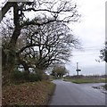
8
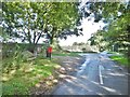
No through road serving Highwood and nearby farms
Image: © David Smith
Taken: 13 Feb 2016
0.24 miles
9
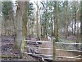
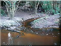
Stream in the woods north of Highwood Heath
A muddy stream after a spell of heavy rain
Image: © David Smith
Taken: 13 Feb 2016
0.25 miles
10
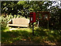
East Stoke: postbox № BH20 220
This postbox is flanked by a village noticeboard and a stone seat, which latter is inscribed: In devoted memory of William George Langdown 1886-1961, his wife Daisy 1891-1980, their daughter Hilda Joan Bowditch 1920-1977 and their forbears. The postbox is emptied finally at 4pm on weekdays and at 8:45am on Saturdays.
Image: © Chris Downer
Taken: 25 Jul 2009
0.25 miles